Geographical outlook of ancient and medieval. Geography of the Middle Ages
The first information about geographical ideas appeared from the moment of writing. One can testify to the existence of two independent centers of geographical thought of the ancient world: Greco-Roman and Chinese. The thinkers of the ancient period described the world close to them in some detail, and also added a lot of fantastic things about distant lands. The combination of materialistic and idealistic views is a characteristic feature of ancient scientists. Many philosophers and historians dealt with geography. At that time there was no SEG, even a single geography was a reference branch of knowledge. In ancient times, two directions arose: 1) a description of special countries, their nature, the ethnic make-up of the population, etc. (Herodotus, Strabo, etc.); 2) the study of the Earth as a whole, its place relative to other planets, its shape and size (Ptolemy, Eratosthenes, etc.). The first direction was called regional geography, the second - general geography.
In European culture, the father of geography and history is the Greek Herodotus, who traveled a lot and in his descriptions spoke about distant lands and previously unknown peoples. Herodotus can also be considered the father of ethnography, because he vividly described the traditions of other peoples. He also gave rise to geographical determinism.
The second outstanding Greek, Aristotle, developed the concept of the different affiliation of the Earth for human life and dependence on geographic latitude. He presented the conditions of settlement as a function of geographical latitude, gave instructions on the best location of cities. The ideas of Aristotle were the basis for the development of science in Europe in the early Middle Ages.
Between 330 - 300 years. BC. Pytheas traveled to the northwestern part of Europe. He described the way of life and occupations of the inhabitants of the British Isles, discovered Iceland. He noted a change in the nature of agriculture from south to north. Pytheas made the first scientific journey, i.e. travel for the purpose of scientific research. Upon returning home, no one believed him at the expense of what he saw, but in vain, because. he first drew attention to the phenomena that today constitute the interests of agricultural geography.
At the beginning of our era in Greece there already existed a guide for navigators (periples) and travelers (periges). The peripluses described in detail the sea coasts and ports. Periplus covered the coasts of the Mediterranean and Black Seas, the eastern coast of Africa. The authors of perigeses were more often logographers, i.e. writers who traveled the earth and described what they saw. Logographs made up specific geographical descriptions, in which special attention was paid to the life of the local population.
The campaigns of Alexander the Great (4th century BC) contributed to the spread of Greek culture. They were attended by scientists who collected information about various lands.
Unlike the Greek thinkers, the Romans contributed less to the field of geography. But even among them, original researchers can be noted. For government officials and military representatives of the Roman Empire, the ancient Greek geographer and historian Strabo created his "Geography". He considered it his task to provide the necessary information about the world, so this work was the first of its kind "reference book for the leadership apparatus." Strabo believed that every geographer should have mathematical knowledge. Strabo's "Geography" was found only 600 years after it was written, and those to whom this book was intended never saw it.
The ancient Romans were warlike and enterprising. Quite often, they expanded their geographical horizons through military campaigns.
At this time, in the east of Asia, there was another center of geographical thought - China. In general, the European and Chinese worlds were reliably isolated from each other, but over time they gradually recognized themselves and their neighbors.
Chinese philosophers differed from Greek philosophers mainly in that they gave paramount importance to the natural world. The geographical works of Chinese scientists can be divided into 8 groups: 1) works devoted to the study of people; 2) description of the regions of China; 3) description of other countries; 4) about travel; 5) books about the rivers of China; 6) description of the coasts of China; 7) local history works; 8) geographical encyclopedias.
The ancient Romans, unlike the ancient Greeks, were great pragmatists. They mainly collected various information about countries, while the Greeks were more inclined to generalize materials. The ancient Chinese combined these traits together. SEG is an ancient science, because the life and production activities of mankind are inseparable from the natural and social environment, so society sought to actively study them. Practical requirements in the ancient period made it necessary to study the natural conditions, population, natural wealth, settlements and communication routes, the economy of one's own and neighboring countries.
Development geographical ideas in the Middle Ages
During the early Middle Ages, the productive forces were underdeveloped - science was under the influence of religion. In Christian Europe, the perception of the world has decreased to the size of the lands mastered by man. Most of the materialistic ideas of ancient scientists were considered heretical. At that time, religion accompanied the development of new knowledge: chronicles, descriptions, and books arose in monasteries. This period is characterized by isolation, separation and mass ignorance of people. The crusades raised large masses of people from their places of residence who left their native places. Returning home, they brought rich trophies and information about other countries. During this period, the Arabs, Normans and Chinese made a great contribution to the development of geography. In the Middle Ages, the geographical science of China achieved great success. Between antiquity and the Middle Ages there was no deep abyss, as was believed by most scholars. In Western Europe, some geographical ideas of the ancient world were known. But at that time, scientists were not yet familiar with the writings of Aristotle, Strabo, Ptolemy. Philosophers of this time used mainly retellings of the writings of commentators on Aristotle's texts. Instead of the ancient naturalistic perception of nature, there was a mystical perception of it.
In the period of the early Middle Ages, starting from the 7th century, Arab scientists played an important role. With the expansion of the Arab expansion to the West, they became acquainted with the writings of ancient scholars. The geographical outlook of the Arabs was wide, they traded with many Mediterranean, Eastern and African countries. The Arab world was a "bridge" between Western and Eastern cultures. At the end of the XIV century. The Arabs made a great contribution to the development of cartography.
Some modern scholars consider Albertus Magnus the first European commentator on Aristotle's writings. He gave descriptions of different areas. It was the time of collecting new factual material, the time of empirical research using the analytical method, but with a scholastic contribution. Probably, that is why the monks, who revived some of the ideas of ancient geography, were engaged in this work.
Some Western scholars associate the development of economic geography with the name of Marco Polo, who wrote a book about life in China.
IN XII-XIII centuries some economic recovery began to appear in Europe, which was reflected in the development of crafts, trade, and commodity-money relations. After the 15th century Geographical research stopped both in China and in the Muslim world. But in Europe they began to expand. The main driving force behind this was the spread of Christianity and the need for precious metals and hot spices. The era of the great geographical discoveries gave a powerful impetus to the overall development of society and also the social sciences.
In the period of the late Middle Ages (XIV-XV centuries), SEG began to form as a science. At the beginning of this period, in the development of geographical science, a desire for "historical geography" was revealed, when researchers were looking for the location of objects that ancient thinkers spoke about in their writings.
Some scientists believe that the first economic and geographical work in history is the work of the Italian geographer Guicciardini “Description of the Netherlands”, which was published in 1567. He gave a general description of the Netherlands, including an analysis of the geographical location, an assessment of the role of the sea and in the life of the country, state of manufacture and trade. Much attention was paid to the description of cities, and especially Antwerp. The work was illustrated with maps and city plans.
The theoretical substantiation of geography as a science was first made in 1650 by the geographer B. Varenius in the Netherlands. In the book "General Geography" he emphasized the trend of differentiation of geography, showed the connection between the geography of specific places and general geography. According to Varenius, works that characterize special places must be attributed to special geography. And works that describe general, universal laws that apply to all places - general geography. Varenius considered special geography to be the most important for practical activities, especially in the field of trade and economic relations between countries. General geography provides these foundations, and they must be rooted in practice. Thus, Varenius defined the subject of geography, the main methods of studying this science, showed that special and general geography are two interconnected and interacting parts of the whole. Varenius considered it necessary to characterize the inhabitants, their appearance, crafts, trade, culture, language, methods of government or state structure, religion, cities, significant places and famous people.
At the end of the Middle Ages, geographical knowledge from Western Europe reached the territory of Belarus. Belsky in 1551 published the first work in Polish on world geography, which was later translated into Belarusian and Russian, which testified to the spread of knowledge about the great geographical discoveries and different countries of the world in Eastern Europe.
- Subject of historical geography
- The subject of historical geography - page 2
- The history of the emergence and development of historical geography
- Geographical environment and development of society in the feudal era
- Geographical environment and development of society in the feudal era - page 2
- Physical-geographical zoning of Western Europe
- Physical-geographical zoning of Western Europe - page 2
- Physical-geographical zoning of Western Europe - page 3
- Physical-geographical zoning of Western Europe - page 4
- Distinctive features of the physical geography of the Middle Ages
- Distinctive features of the physical geography of the Middle Ages - page 2
- Distinctive features of the physical geography of the Middle Ages - page 3
- Subject of historical geography
- Population geography and political geography
- Ethnic map of medieval Europe
- Ethnic map of medieval Europe - page 2
- Political map of Europe during the early Middle Ages
- Political map of Europe during the early Middle Ages - page 2
- Political map of Europe during the early Middle Ages - page 3
- Political geography of Western Europe in the period of developed feudalism
- Political geography of Western Europe in the period of developed feudalism - page 2
- Political geography of Western Europe in the period of developed feudalism - page 3
- social geography
- Social geography - page 2
- Population size, composition and distribution
- Population, composition and distribution - page 2
- Population, its composition and distribution - page 3
- Types of rural settlements
- Medieval cities of Western Europe
- Medieval cities of Western Europe - page 2
- Medieval cities of Western Europe - page 3
- Ecclesiastical Geography of Medieval Europe
- Some features of the geography of medieval culture
- Ethnic map of medieval Europe
- Economical geography
- The development of agriculture in the early and advanced Middle Ages
- Farming and land use systems
- Farming and land use systems - page 2
- Features of the agrarian system in various countries of Western Europe
- Features of the agrarian system in various countries of Western Europe - page 2
- Geography of craft and trade
- Features of the placement of medieval handicraft production
- wool production
- Mining, metalworking shipbuilding
- Geography of the crafts of individual countries of Western Europe
- Geography of handicrafts of individual countries of Western Europe - page 2
- medieval trade
- mediterranean trade area
- Mediterranean Trade Area - page 2
- Northern European Trade Area
- Areas of monetary systems
- Transport and communications
- Transport and communications - page 2
- Geographical representations and discoveries of the early and advanced Middle Ages
-
- Geographical representations of the early Middle Ages - page 2
- Geographical representations and discoveries of the era of the developed Middle Ages
- Cartography of the Early and Advanced Middle Ages
-
- Historical geography of Western Europe in the late Middle Ages (XVI - first half of the XVII century)
- political map
- Political map - page 2
- social geography
- Demographics of the Late Middle Ages
- Demographics of the Late Middle Ages - page 2
- Demographics of the Late Middle Ages - page 3
- Church geography
- Geography of agriculture
- Geography of agriculture - page 2
- Industry geography
- Industry geography - page 2
- Industry geography - page 3
- Trade of late feudalism
- Trade of late feudalism - page 2
- Trade of late feudalism - page 3
- Transport and communications
- Travels and discoveries of the XVI-XVII centuries.
- Travels and discoveries of the XVI-XVII centuries. - page 2
- Travels and discoveries of the XVI-XVII centuries. - page 3
- political map
Geographic representations of the early Middle Ages
Geography in antiquity reached a high level of development. Ancient geographers adhered to the doctrine of the sphericity of the earth and had a fairly correct idea of its size. In their writings, the doctrine of climate and the five climatic zones of the globe was developed, the question of the predominance of land or sea was sharply debated (dispute between oceanic and land theories). The pinnacle of ancient achievements was the cosmogonic and geographical theory of Ptolemy (2nd century AD), despite its shortcomings and inaccuracies, and unsurpassed until the 16th century.
The Middle Ages wiped ancient knowledge off the face of the earth. The dominance of the church in all areas of culture also meant a complete decline in geographical concepts: geography and cosmogony were entirely subordinated to the needs of the church. Even Ptolemy, left in the role of supreme authority in this area, was emasculated and adapted to the needs of religion. The Bible became the supreme authority in the field of cosmogony and geography; all geographical representations were based on its data and aimed at explaining them.
"Theories" about the earth floating in the ocean on whales or turtles, about the precisely outlined "end of the earth", about the firmament supported by pillars, etc., were widely spread. Geography obeyed the biblical canons: Jerusalem was located in the center of the earth, beyond the lands of Gog and Magog, there was a paradise from which Adam and Eve were expelled, all these lands were washed by the ocean that arose as a result of the global flood.
One of the most popular at that time was the “geographical theory” of the Alexandrian merchant, and then the monk Kozma Indikoplov (Indikopleist, that is, who sailed to India), who lived in the first half of the 6th century. He "proved" that the earth has the form of "the tabernacle of Moses", i.e. the tent of the biblical prophet Moses - a rectangle with a ratio of length to width as 2: 1 and a semicircular vault. An ocean with four bays-seas (Roman, that is, the Mediterranean, Red, Persian and Caspian) separates the inhabited land from the eastern land, where paradise is located and from where the Nile, Ganges, Tigris and Euphrates originate. In the northern part of the land there is a high mountain, around which the celestial spheres revolve, in summer, when the sun is high, it does not hide behind the top for long, and therefore summer nights are short compared to winter, when it goes behind the foot of the mountain.
Views of this kind, of course, were supported by the church as "true", corresponding to the spirit of Holy Scripture. It is not surprising that as a result of this, absolutely fantastic information was spread in Western European society about various regions and the peoples inhabiting them - people with dog heads and generally headless, having four eyes, living with the smell of apples, etc. A perverted legend, or even just fiction , which has no soil, became the basis of geographical representations of that era.
One of these legends, however, played a significant role in the political and social life of the early and developed Middle Ages; this is a legend about the Christian state of the priest John, allegedly located somewhere in the east. Now it is already difficult to determine what is at the heart of this legend - either vague ideas about the Christians of Ethiopia, Transcaucasia, the Nestorians of China, or a simple fiction, caused by the hope of outside help in the fight against a formidable enemy. In search of this state, a natural ally of the European Christian countries in their struggle against the Arabs and Turks, various embassies and travels were undertaken.
Against the background of the primitive views of the Christian West, the geographical representations of the Arabs stand out sharply. Arab travelers and navigators already in the early Middle Ages collected a huge amount of data about many countries, including distant ones. “The outlook of the Arabs,” according to the Soviet Arabist I. Yu. Krachkovsky, “embraced in essence the whole of Europe with the exception of the Far North, the southern half of Asia, North Africa ... and the coast of East Africa ... The Arabs gave a complete description of all countries from Spain to Turkestan and the mouth of the Indus with a detailed enumeration of settlements, with a description of cultural spaces and deserts, indicating the scope of distribution of cultivated plants, locations of minerals.
The Arabs also played a big role in the preservation of the ancient geographical heritage, already in the 9th century. translating into Arabic the geographical writings of Ptolemy. True, having accumulated a huge wealth of information about the world around them, the Arabs did not create major generalizing works that would theoretically comprehend all this baggage; their general concepts of the structure of the earth's surface did not exceed Ptolemy's. However, it was precisely because of this that Arabic geographical science had a great influence on the science of the Christian West.
Travels of the early Middle Ages were random, episodic. They were not faced with geographical tasks: the expansion of geographical representations was only a passing consequence of the main goals of these expeditions. And they were most often religious motives (pilgrimages and missionaries), trade or diplomatic goals, sometimes military conquests (often robbery). Naturally, the geographical information obtained in this way was fantastic and inaccurate, not long retained in people's memory.
Pages: 1 2
Topic 1. The main stages in the development of geography
The study of the content of the paragraph provides an opportunity
Ø supplement ideas about the origins of geographical knowledge;
Ø to study the stages and features of the development of geographical knowledge at each of the historical stages of the development of society;
initial stage in the history of the development of geographical science are the geographical knowledge of primitive peoples. They needed geographical knowledge in everyday life, and the direction of knowledge was determined by the nature of the occupation. They were associated with the need to find and locate the best pastures, soils, hunting and fishing grounds, and settlement sites. Geographical knowledge was based on intuition, observation, knowledge of natural phenomena and the ability to see their relationships and patterns. Thanks to writing, geographical knowledge of the peoples of ancient civilized countries (Egypt, Mesopotamia, Sumer, Babylon, China) has reached our time. ( Recall what research has been done in these countries?).
Geography of Antiquity. The geography of ancient times covers the VI century. BC e - IV c. e., and it distinguishes the ancient Greek (VI-I centuries BC) and ancient Roman (I-IV centuries AD) periods.
Ancient scientists tried to create a theory about the origin and structure of the surrounding world, to depict the countries known to them in the form of drawings. The results of these searches were the idea of the Earth as a ball, and then its scientific proof; creation of maps and determination of geographical coordinates, introduction of parallels and meridians, cartographic projections.
Summarizing ideas about the Earth and the solar system, the Greeks created a system of knowledge called musical-numerical system of the Universe. The name is due to the fact that the sequence of removal of the planets from the Sun and the distance between them was equated to the musical scale. Later appeared geocentric and heliocentric models of the Universe (Remember from the course of history, what are these models of the Universe?).
The main source of geographical information and geographical knowledge for the ancient Greeks was land and sea travel. The Greeks called the description of sea voyages "peripluses", and land "perieges". The performers of the perieges were "logographs", who traveled overland and made a description of everything that they observed in nature, but paid special attention to the customs and life of the population.
Of the scientists of this time who contributed to the development of geographical thought, Thales, Aristotle, Eratosthenes, Strabo and Ptolemy should be distinguished ( Remember from the history course when these scientists lived?).
At the beginning of a new era, the geographical knowledge of Greek scientists was systematized by the ancient Greek scientist Strabo. He argued that the surface of the Earth is constantly changing, and the distribution of land and sea is the result of ups and downs of the seabed.
Ancient geography ends with works Claudius Ptolemy. It is known that Ptolemy is the author of the Almagest, a classic astronomical work in which the Earth was proclaimed the center of the Universe. Ptolemy did a lot for the development of cartography. He calculated the coordinates of 8000 geographical points. Created about 30 geographical maps of various areas of the earth's surface.
Thus, already in ancient times, the future began to emerge within geography. regional studies(Strabo), mathematical geography(Eratosthenes, Ptolemy) and some other natural geographical sciences.
Geography of the Middle Ages (VI-XV centuries). During the Middle Ages, under the strong influence of religion, many of the materialistic views of ancient scientists were forgotten or rejected as anti-religious. But, despite the general stagnation in the development of science, culture, education, inherent in the Middle Ages, some geographical discoveries took place at that time. First of all, they were associated with the campaigns and discoveries of new lands by the Scandinavians and the geographical discoveries of scientists from the Arab countries (scientists and travelers Ibn Sina (Avicenna), Biruni, Idrisi, Ibn Batuta). ( Remember from history when and where these scientists lived?).
The Vikings discovered and then founded in the IX-XI centuries. the first settlements in Iceland, Greenland and North America.
Arab scholars in the X century. created the first climate atlas of the world, highlighting 14 climatic zones on the planet and establishing that the climate changes not only in latitudes, but also from west to east.
Arabic medieval geographical literature is diverse. Known are such works of medieval Arab scholars as "The Book of Ways and States", "Wonders of the Countries" or "Wonders of the Earth", as well as geographical sections in historical writings.
During the Middle Ages, a relatively high level of science and culture was maintained in Byzantium. This is explained by the fact that Byzantine scientists were able to adopt and develop many traditions of ancient geographers.
The era of the great geographical discoveries. The most significant discoveries on land and at sea, made in the XV-XVIII centuries, are called Great geographical discoveries. The era of the great geographical discoveries is the flourishing of geography against the backdrop of a general rise (revival) of culture and science. The era of the Great Geographical Discoveries was marked by grandiose achievements, both in the field of territorial discoveries and in the field of scientific theories and research methods.
The search for new lands and routes was carried out on a state scale. The fixation of acquired knowledge, mapping and generalization of the information received has become more important ( What role did F. Magellan, H. Columbus play in the discovery of new lands during this historical period).
When new lands were discovered, a need arose for their cartographic representation and description. This led to the formation scientific cartography. Flemish cartographer Gerhard Mercator(1512-1594) created the first cylindrical conformal projection of the world map, which is still used today and bears the name of Mercator. He also developed a method for using isotherms for climate mapping and hypsometric curve method to characterize the relief, he compiled a collection of maps and descriptions of European countries, which, when published in 1595, was called the Atlas.
Questions and tasks:
1. What determines the main differences between the geography of antiquity and the geography of the Middle Ages?
2. Why do you think it was in the Arab countries that geography developed especially rapidly in the Middle Ages?
3. What achievements in other fields of knowledge contributed to the development of geography?
4. * What needs of society did geography satisfy in the era of the Great Geographical Discoveries?
Geography of the Middle Ages (from the 5th to the 17th centuries).
The Middle Ages include the period from the 5th to the 17th century. It is also generally accepted that this period was characterized by a general decline in relation to the previous brilliant period of Antiquity.
In general, in the Middle Ages, the development of geographical knowledge continued within the framework of the country studies direction. The main carriers of geographical knowledge are merchants, officials, soldiers and missionaries. Thus, the Middle Ages were not fruitless, especially with regard to spatial discoveries (Markov, 1978).
In the Middle Ages, two main "worlds" can be distinguished in terms of the development of geographical representations - Arabic and European.
IN Arab world the traditions of ancient science were largely adopted, but in geography, the regional study trend was most preserved. This is due to the vastness of the Arab Caliphate, which stretched from Central Asia to the Iberian Peninsula.
Arabic geography was of a reference nature and had more practical meaning than speculative. The earliest summary of this kind is the “Book of Ways and States” (IX century), written by the official Ibn Hardadbek.
Among travelers, the wandering Moroccan merchant Abu Abdullah Ibn Battuta, who traveled to Egypt, Western Arabia, Yemen, Syria, and Iran, achieved the greatest success. Was also in the Crimea, on the lower Volga, in Central Asia and India. On his last journey in 1352-1353. he crossed Western and Central Sahara.
Among the prominent Arab scientists dealing with geographical issues, Biruni can be noted. This great Khorezm scholar-encyclopedist was the greatest geographer in the 11th century. In his research, Biruni wrote about erosion processes and sorting of alluvium. He gave information about the ideas of the Hindus, about the connection of the tides with the moon.
Despite these isolated achievements, Arabic geography did not surpass ancient geography in terms of theoretical concepts. The main merit of Arab scientists was to expand their spatial horizons.
IN medieval Europe, as in the Arab world, the main contribution to the development of geographical knowledge was made by travelers. It should be noted that, unlike the Arabs, the theoretical achievements of ancient geographers were sometimes rejected. For example, one of the well-known medieval geographical works is "Christian Geography" by Kozma Indikoplova (VI century). This book provides country-specific information on Europe, India, Sri Lanka. At the same time, it resolutely rejects the sphericity of the Earth, which is recognized as a delusion.
The expansion of the geographical outlook of Europeans began after the 10th century, which was associated with the beginning of the Crusades (XI-XII centuries). Subsequently, significant geographical discoveries were obtained as a result of the embassy missions of the Catholic Church to the Mongol khanates.
Among the prominent European travelers of the Middle Ages, one can note Marco Polo, who visited and studied China in the 4th century, as well as the Russian merchant Athanasius Nikitin, who described in the 15th century. India.
At the end of the Middle Ages, geographical travel began to be carried out purposefully. Particularly noticeable in this regard is the activity of the Portuguese prince Henry, nicknamed the Navigator (1394-1460). The captains of Henry the Navigator explored the West Coast of Africa step by step, discovering, in particular, the Cape of Good Hope (Golubchik, 1998).
In general, it can be noted that in the Middle Ages, geography was not much different from ancient times, as in ancient times, it was the same. It covered the entire sum of the then knowledge about the nature of the earth's surface, as well as about the occupations and life of the peoples inhabiting it. According to academician I.P. Gerasimov, it provided the economic activity of people with the necessary scientific information about the natural conditions and resources of the developed territories and supplied internal and external political actions with the most complete information about near and far countries (Maksakovsky, 1998).
Separately, in medieval times in Europe, the era of the Great Geographical Discoveries stands out - they close this stage in the development of geography and represent a bright and unique action, as a result of which the main elements of the modern geographical picture of the world were formed.
The Middle Ages (V-XV centuries) in Europe are characterized by a general decline in the development of science. The feudal isolation and religious worldview of the Middle Ages did not contribute to the development of interest in the study of nature. The teachings of ancient scientists were uprooted by the Christian church as "pagan". However, the spatial geographical outlook of Europeans in the Middle Ages began to expand rapidly, which led to significant territorial discoveries in different parts of the globe.
The Normans (“northern people”) first sailed from Southern Scandinavia to the Baltic and Black Seas (“the route from the Varangians to the Greeks”), then to the Mediterranean Sea. Around 867, they colonized Iceland; in 982, led by Leif Erikson, they opened the east coast of North America, penetrating south to 45-40? NL
The Arabs, moving westward, in 711 penetrated the Iberian Peninsula, in the south - into the Indian Ocean, up to Madagascar (IX century), in the east - into China, from the south went around Asia.
Only from the middle of the XIII century. the spatial horizons of Europeans began to noticeably expand (the journey of Plano Carpini, Guillaume Rubruk, Marco Polo and others).
Marco Polo (1254-1324), Italian merchant and traveler. In 1271-1295. traveled through Central Asia to China, where he lived for about 17 years. Being in the service of the Mongol Khan, he visited different parts of China and the regions bordering it. The first of the Europeans described China, the countries of Western and Central Asia in the "Book of Marco Polo". It is characteristic that contemporaries treated its content with distrust, only in the second half of the 14th and 15th centuries. they began to appreciate it, and up to the 16th century. it served as one of the main sources for compiling the map of Asia.
The journey of the Russian merchant Athanasius Nikitin should also be attributed to a series of such trips. In 1466, with trading purposes, he set off from Tver along the Volga to Derbent, crossed the Caspian and reached India through Persia. On the way back, three years later, he returned through Persia and the Black Sea. The notes made by Afanasy Nikitin during the trip are known as "Journey Beyond the Three Seas". They contain information about the population, economy, religion, customs and nature of India.
More on the topic § 2. Geography of the Middle Ages:
- 2.4. Philosophical problems of geography 2.4.1. The place of geography in the genetic classification of sciences and its internal structure
Geography in feudal Europe
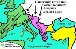
Slave-owning society, starting from the end of the $II$ c. experienced a deep crisis. The strengthening of Christianity and the invasion of the Gothic tribes contributed to the acceleration of the decline of Roman-Greek culture and science. The Roman Empire in $395$ was divided into Western And Eastern part, and in $476$ the Western Roman Empire ceases to exist. Trade relations are significantly reduced, and Christian pilgrimages to the "holy places" - to Palestine and Jerusalem, remain the main incentive for the knowledge of distant countries. In geography, no new ideas appeared; at best, the old knowledge was preserved, no longer complete and rather distorted. In this form, they passed into the Middle Ages.
The Middle Ages are a period of decline when the spatial and scientific horizons of geography narrowed sharply, and the geographical knowledge and ideas of the ancient Greeks and Phoenicians were simply forgotten. Only among Arab scholars did the old knowledge still survive. The horizons of geographical science began to expand rapidly at the end of the $15th century. with the beginning of the Age of Discovery.
Remark 1
Word "geography" in Christian Europe of the Middle Ages it practically disappeared, although its study continued. Curiosity and the desire to find out what distant lands are made adventurers go on trips. Merchants and missionaries in the $XIII$ c. made their way all the way to China.
Biblical dogmas and some conclusions of ancient science, cleared of everything “pagan”, gave geographical representations in the early Middle Ages. So, for example, in "Christian Topography" Cosmas Indikopov, it was said that the Earth has the form of a flat rectangle around which there is an ocean, the sun hides behind the mountains at night, and all large rivers originate in paradise and flow under the ocean. Discoveries during this period were repeated, i.e. “opened” for the second, third and even fourth time.
The most prominent place in the early Middle Ages belongs to Scandinavian Vikings who devastated England, Germany, Flanders, France with their raids. Scandinavian merchants traveled to Byzantium along the Russian route "from the Varangians to the Greeks." Having rediscovered Iceland in $866$, the Normans firmly settled there. In $983$, Eric the Red discovered Greenland, where their permanent settlements arose.
A relatively wide spatial outlook in the first centuries of the Middle Ages had Byzantines . Their religious ties extended to the Balkan Peninsula, later to Kievan Rus and Asia Minor. Religious preachers reached India, penetrating Central Asia, Mongolia, and the western regions of China.
According to "Tales of Bygone Years"(Chronicle of Nestor), the spatial outlook of the Slavic peoples extended almost to the whole of Europe.
Geography in the Scandinavian world
Excellent sailors of that time were Scandinavians . Those who were of Norwegian origin were called Vikings. It was they who, in $874$, approached the shores of Iceland and founded the first settlement. The world's first parliament, the Althingi, was established here in $930.
The history of geography says that among the Icelanders there was Eric the Red. For a stormy and violent temper, along with his family and friends, he is expelled from the country. He had no choice but to embark on a long voyage across the Atlantic, especially since Eric had heard about the existence of land there. It turned out that the rumors were confirmed - it was Greenland. Translated into Russian - green land, green country. It is not clear why Eric gave such a name - there was nothing green around. He founded a colony here, which attracted some Icelanders. Later, close maritime ties were established between Greenland, Iceland, and Norway.
Remark 2
Sometimes accidents lead to big and important discoveries, so it happened with the son of Eric, who, returning from Greenland to Norway, got into a strong storm. This event happened around $1000$, the ship went off course and ended up on an unfamiliar coast. Leif Eirikson- the son of Eric, found himself in a dense forest, the trees of which were entwined with wild grapes. Far to the west lay an unknown land, which much later was called North America.
Geography in the Arab world
The development of world culture from $VI$ c. characterized by a prominent role Arabs , which to $VIII$ c. created a huge state. It included the whole of Western Asia, part of Central Asia, the northwestern part of India, North Africa and most of the Iberian Peninsula. The main occupation of the Arabs was craft and trade with China and African countries.
The decentralization of the Arab Caliphate, which began in the $8th century, led to the emergence of large scientific and cultural centers in Persia, Spain, and North Africa. Scientists of Central Asia wrote in Arabic, the works of Greek scientists Plato, Aristotle, Hippocrates, Strabo, etc. were translated into it. At that time, geography in the Arab world was considered as "the science of postal communication."
The most popular type of Arabic literature is the description of travel, in which information of a nomenclature and historical-political nature predominates. It must be said that scientists who wrote in the slave language in the interpretation of physical and geographical phenomena did not contribute anything new and significant. The theoretical ideas of the Arabs remained primitive, they did not bother to develop new concepts. Having collected a large amount of material in the field of physical geography, they failed to process it into a coherent scientific system. Despite this, their role in the history of science remains significant. For example, the new system of "Arabic" numbers that spread in Western Europe, arithmetic, astronomy, Arabic translations of Greek authors. Among the Arab travelers one can name such names as Ibn Haukal, who traveled through the remote regions of Africa and Asia, Al-Balkhi, who summarized information about climatic phenomena in the first climate atlas of the world, Masudi, who visited Mozambique and made accurate descriptions of the monsoons.
Remark 3
Some Arab scholars made correct assumptions about the formation of the forms of the earth's surface, among them the famous scientist Avicenna. One of the greatest Arab travelers was Ibn Battuta. He managed to visit Mecca, visit Ethiopia, go through the Red Sea. He was later appointed ambassador to China. In about thirty years, Ibn Battura covered a distance of $120$ thousand km.
The Development of Geography in Medieval China
Up to $XV$ c. had the highest level of knowledge Chinese people. Suffice it to say that Chinese mathematicians used zero and created a decimal, more convenient, calculus system. Chinese philosophers attached paramount importance to the natural world, thus differing from the thinkers of ancient Greece. The activity of the Chinese in the field of geographical research looks very impressive. Chinese geographical research was associated with the creation of methods that made it possible to make accurate measurements and observations. Chinese engineers back in the $II$ c. BC. measured the amount of silt carried by rivers, conducted the world's first population census, learned how to make paper and print books. Rain gauges and snow gauges were used to measure the amount of precipitation.
Evidence of the earliest Chinese travels is presented in a book called "Journey of Emperor Mu". The book was written between $V-III$ centuries. BC. and was found in the tomb of a man who ruled during his lifetime the territory that occupied part of the Wei He valley. For better preservation, the book was written on strips of white silk glued to bamboo cuttings.
In the Middle Ages, famous travel descriptions belong to Chinese pilgrims who visited India and its surrounding areas. Sufficiently accurate information about the population, climate, flora of Samarkand was collected in $1221$ by the Taoist monk Chan Chun. Each new Chinese dynasty in the Middle Ages compiled numerous official descriptions of the country, which contained a variety of information on the history, natural conditions, population, economy and sights of the country. This fairly broad geographical knowledge did not affect the horizons of Europeans; moreover, the geographical representations of medieval Europe in India and China also remained almost unknown.
Late Middle Ages in Europe (XII-XV centuries)
To replace the feudal stagnation in the economic development of the countries of Western Europe in the $XII$ century. some uplift comes. Craft, trade, commodity-money relations begin to revive again. During this period, the Mediterranean region was the main economic and cultural center, and this is understandable - trade routes to the East passed here.
Later, already in the $XIV$ century, busy trade routes moved to the north - to the region of the Baltic and North Seas. At this time, paper and gunpowder appeared in Europe. Sailing and rowing ships were replaced by caravels, a compass was used, and the first sea charts were created - portolans.
International relations, navigation are developing, cities are growing. All this contributes to the expansion of spatial horizons, arouses the keen interest of Europeans in geographical knowledge and discoveries, an important factor in which were the crusades between $1096-1270$. under the pretext of liberating the Holy Land.
In the middle of $XIII$ c. there comes a noticeable turning point in the development of geographical representations, one of the reasons for which was the Mongol expansion.
Remark 4
During this period there are such names as Marco Polo who traveled through China, to India, Ceylon, Arabia and East Africa. Russian Novgorodians who discovered all the major rivers of the European North and paved the way to the Ob basin. Moving east along the northern shores of Eurasia, Russian sailors explored the southwestern coast of the Kara Sea, the Ob and Taz Bays. In $XV$ c. the Russians sailed to the Svalbard archipelago, which at that time was called Grumant.
Known are the names of Prince Henry the Navigator, Jakome from Mallorca, Gila Eanisha, Bartolomeu Dias.
The development of geographical knowledge in the era of the Middle Ages (III - the end of the XV centuries) is characterized by the development of almost exclusively regional studies. Other areas related to mathematics and fundamental natural sciences have not received any development and have even been largely forgotten.
Only in the Arab world were some of the ideas of antiquity preserved, without, however, receiving further development. The main carriers of geographical knowledge were merchants, officials, military men and missionaries, for whom regional knowledge was the basis of their practical activities or public service.
The greatest development of country studies (mainly in the form of special geographical works) was received in the Arab world. This was due to the vastness of the Arab Caliphate, which, starting from the 8th century, gradually expanded from Central Asia to the Iberian Peninsula. One of the important factors in the development of regional studies was the intermediary nature of Arab trade between East and West in their traditional sense.
Arabic geographic works were of a reference nature, they provided information about peoples, wealth, crossings, settlements and trade items. An example is the earliest summary of this kind, dating back to the middle of the 9th century, - "The Book of Ways and States" by Ibn Hardadbek, an official under the Caliph of Baghdad. Such is the most complete multi-volume "Geographical Dictionary" of the first quarter of the 13th century, written by a Muslim from the Byzantine Greeks, Yakut (1179-1229)14.
One of the greatest connoisseurs of Arabic geographical literature, Academician I. Yu. Krachkovsky, characterizes the scientific significance of the traveller's notes in this way: This may be why his book turned out to be the only one of its kind description of Muslim and Eastern society in general in the 14th century. This is a rich treasury not only for the historical geography of its time, but for the entire culture of that era "15.
The ecological direction of geography among the Arabs had the character of vulgar determinism, praising the climate of the Arabian Peninsula, one of the seven "climates", which, in contrast to the latitudinal climates of the Greeks, meant large regions of the world.
Some of the great Arab scientists rose to the level of genetic and cosmogonic reasoning, but they also failed to rise to the level of ancient Greek scientists. So, the Baghdad Arab Masudi, in the X century. visited the Mozambique Channel, made the first description of the monsoons, and also wrote about the evaporation of moisture from the surface of the water and subsequent condensation in the form of clouds. The great Khorezm scientist-encyclopedist Biruni was also the greatest geographer of the 11th century. During his long travels he explored the Iranian Plateau and much of Central Asia. Accompanying the conqueror of Khorezm, the Afghan sultan Mahmud Ghaznevi, on his devastating campaign against the Punjab, Biruni collected extensive materials on Indian culture there and put them, together with personal observations, into the basis of a great work on India. In this work, Biruni, in particular, writes about erosion processes, sorting of alluvium, and finds of sea shells high in the mountains. He gives information about the ideas of the Hindus about the connection of the tides with the moon.
The outstanding scientist, philosopher, physician and musician Ibn Sina (Latinized Avicenna) (c. 980-1037) wrote about denudation processes. He described the results of his direct observations on the development of the valley by the large rivers of Central Asia and, on this basis, put forward the idea of the continuous destruction of mountainous countries. He pointed out that the mountains begin to wear down in the process of uplift and that this process goes on continuously. But, despite these (and other) individual achievements, Arabic geography in the sense of theoretical concepts has not advanced further than the ancient geographers. Her merit lies mainly in expanding the spatial horizons and in preserving the ideas of antiquity for posterity.
The maps of the Arabs, which until the 15th century, also speak of a low level of theoretical ideas. built without a grid. On these maps, correct geometric figures were used to depict geographical objects - circles, straight lines, rectangles, ovals, which unrecognizably changed nature. "For fear of idolatry, the Koran forbade depicting people and animals. This prohibition was also reflected on geographical maps, which were drawn as diagrams using a compass and a ruler."
The exception is the maps of al-Idrisi (1100-1165). In 1154 his "Geographical Entertainments" appeared. This book, in contrast to the purely descriptive geography reference books of other Arab authors, contained the verification of Ptolemy's ideas and the correction of his errors on the basis of the latest information. In addition, the book included two maps of the world, circular and rectangular, on 70 sheets. It was these maps that departed from the Arabic canons in that geographical objects were depicted on them in natural outlines. True, these maps were also built without a degree grid, i.e., in the sense of mathematical justification, they were inferior to the Ptolemaic ones, but in the nomenclature part they were significantly superior.
Now let us turn to the early Middle Ages in Europe, which is characterized in general by the decline of science. Of the geographical writings of this time, Kozma Indikoplov's "Christian Geography" (6th century) is usually mentioned, where country-specific information is given on Europe, India, Sri Lanka and Ethiopia. The book was fairly well known for its emphatic rejection of the sphericity of the earth as a fallacy.
The dominance of subsistence farming in medieval Europe sharply narrowed the importance of geographical knowledge. Only thanks to the crusades of 1096, 1147-1149 and 1180-1192. Europeans began to need geographical information, and also got acquainted with Arab culture.
Subsequently, significant geographical information was obtained as a result of the embassy missions of the Catholic Church to the Mongol khanates, which flourished most in the 13th century. Among these embassies, the first of such ambassadors is singled out - the Italian, the Franciscan monk Plano Carpini (1245-1247) and the Fleming Guillaume Rubruk (1252-1256), who reached the capital of the great Khan Karakorum in different ways, collected significant ethnographic, historical , political and regional studies material. Of particular interest is Rubruk's account of his embassy mission. He was the first to correctly outline the outlines of the Caspian Sea, according to some experts, he was also the first to establish the main features of the relief of Central Asia, and the fact that China is washed by the ocean from the east. P. Carpini and G. Rubruk "gave Western Europe the first truly reliable description of Central Asia and the Mongolian peoples and thereby opened up a whole new area for research ... This alone gives their works great value, and, in addition, they were pioneers in that movement which opened Asia, albeit for a short time, to intercourse with Europe.
An outstanding geographical phenomenon of the XIII century. one should name the book of the Venetian merchant Marco Polo (1254 - 1344) "On the Diversity of the World" or, as it is usually called now, "The Book of Marco Polo"18. This merchant made a long journey to East Asia (1271-1295), served for a long time with Khan Khubilai in Beijing, which gave him the opportunity to become widely acquainted with the life of the peoples of East Asia. In his book, in addition to a fairly truthful description of many places visited, Marco Polo mentions Japan and the island of Madagascar. Thus, he significantly expanded the spatial horizons of Europeans, for the first time widely and easily introduced them to the riches of the East.
It is characteristic that in 1477 the first printed edition of this book appeared in German translation and it was one of the first printed books in Europe.
Literature of this kind also includes "Journey Beyond Three Seas" by the Tver merchant Athanasius Nikitin, who traveled in 1466-1475. in southern and southwestern Asia, lived for a long time in India. True, his book was discovered and published only in the 19th century, but as an indicator of the level of development and interest in geographical information, the work of A. Nikitin is deservedly mentioned in the history of geographical science. He "was the first European who gave a completely truthful, of great value description of medieval India, which he described simply, realistically, efficiently, without embellishment. By his feat, he convincingly proves that in the second half of the 15th century, 30 years before the Portuguese "discovery" India, even a lonely and poor, but energetic person could make a trip to this country from Europe at his own peril and risk, despite a number of exceptionally unfavorable conditions.
At the end of the period under review, geographical travel began to be undertaken purposefully. In this regard, the activity of the Portuguese prince Enrique (Henry), nicknamed the Navigator (1394-1460), who in 1415 founded a nautical school and an observatory in the city of Segris in the south of Portugal, can be called outstanding. The captains of Enrique the Navigator, step by step, discovered the western coast of Africa, and their geographical discoveries continued until, on the eve of the Age of Discovery, in 1487, Bartolomeu Dias reached the Cape of Good Hope.
A characteristic type of geographical literature of the period under consideration is the so-called commercial geography. In 1333, the "Practice of Trade" by the Italian Pegoletti appeared, which contained information about the quality and technology of manufacturing the most important goods, about units of weight and measure, the monetary units of countries, a description of duties and transport costs, as well as a caravan road from the Sea of \u200b\u200bAzov to China. Starting from the thirteenth century, a certain semblance of a "quantitative" description of states appeared (in the services of governors and diplomatic agents of Italian city-states). To a certain extent, they contained some of the origins of economic geography.
In the field of cartography, the appearance of the compass should be considered an important moment, which caused the creation of the so-called portalans - compass maps, where the degree grid was replaced by intersecting compass points, by which ships' courses were determined. After the advent of the art of copper engraving, these portals became available to a wide range of interested parties. Although they did not have a mathematical basis, the depiction of coastal objects was quite complete and satisfied the unpretentious needs of contemporaries.
Thus, partly speculatively, partly empirically and mathematically justified, the ancient natural philosophers and their Arabic commentators laid the foundations for the main modern trends in the natural science branch of geography. However, their systems, closely related to history and ethnology, were of a humanitarian nature, and therefore in their works one can find thoughts related to the social science branch of geography.
Of course, other outstanding travels and geographical discoveries were made in the Middle Ages, but many of them, for a number of reasons, did not influence the development of human civilization, the development of sciences and, in particular, geography. Among them, the most significant were the voyages of the Normans in the 7th-11th centuries, during which they visited the shores of the White Sea, discovered Iceland, Greenland, and a significant part of the eastern coast of North America. Obviously, such trips should also include the trips of Chinese officials to Central and Southeast Asia, the voyages of Polynesians in the Pacific Ocean, etc. A common reason for the low fame of these outstanding achievements in the world is their economic prematureness. Language barriers also played a role, as did the lack of international formalization of scientific knowledge (for example, in Latin, as was the case in Europe).
The scientists of the period under review described the variety of objects of geography in a certain unity. The integrity of their thinking was manifested in the unification of many aspects of philosophy, history, mathematics, natural science, politics, medicine, ethnography and the beginnings of other sciences. Geographical ideas, not excluding the rare works on geography that have come down to us, unfolded in the unity of these views, without constituting anything sharply specific - geographical material was connected, and in many cases, dissolved in other materials. "I believe that the science of geography, which I have now decided to deal with, as well as any other science, is included in the scope of the philosopher's studies," he wrote in the 1st century. AD Strabo (1964, p. 7). One could also say this: geographical knowledge is one of the first forms of human reflection of the environment, and at the same time geographical objects (mountains, rivers, settlements, etc.) are easily perceived by human physiological receptors, and geographical information is necessary for everyone - hunters , farmers, military, merchants, politicians. Therefore, it is not surprising that geography played an important role in the abstract-holistic constructions of ancient scientists.
“Judging by the information of the official Chinese historical chronicles, already in the XI-VIII centuries. BC e. when choosing sites for the construction of cities and fortresses, the Chinese drew up maps (plans) of the relevant sites and presented them to the government. During the Warring States period (403-221 BC), maps are often mentioned in sources as a necessary means of supporting military operations. In the chronicle of Chu Li (“Rules [rituals] Chu”) it is written that by this time two special government institutions in charge of maps had long been functioning: Ta-Ccy-Ty - “all land maps” and Ssu-Hsien - “center for collecting strategic maps...
In 1973, during the excavations of the Ma-wang-tui burial in the capital of Yunnash province, Changsha, among the weapons and other equipment that accompanied the young commander on his last journey, a lacquer box with three maps made on silk was discovered. The maps were dated to the period before 168 BC. e.
The accuracy of the contours and the rather constant scale of Chinese maps of the 2nd c. BC e. make it quite reasonable to assume that the results of direct surveys on the ground were used in their compilation. The main tool for such surveys, obviously, was the compass, the use of which by Chinese travelers is mentioned already in the 3rd century BC. BC e.
The achievements of Chinese practical cartography were theoretically generalized in the writings of Pei Xu (223/4? - 271 AD) ... The end result of these works was the remarkable “Regional Atlas of Xu Kung”, consisting of 18 sheets and, perhaps, being the oldest of famous regional atlases of the world. In the preface to this work, Pei Xiu, summarizing the achievements of his predecessors and relying on his own experience, formulated six basic principles for the "materialities" of mapping.(From the principles cited by A.V. Postnikov, it follows that the Chinese in the 3rd century knew geometry brilliantly, and from the tools they had not only a compass, but also a mechanical watch and other equipment necessary for performing geodetic work. However, this obviously could not be. - Auth.)
Cartographic principles and techniques, generalized in the work of Pei Xu, dominated Chinese cartography until the penetration of the European cartographic tradition in the 17th-18th centuries ...
In the XII-XIV centuries. the most significant works of Chinese cartography were created, some of which have survived to this day. Widely known, in particular, are maps, remarkable in terms of geographical authenticity, engraved on the front and side sides of one of the steles in the so-called "forest of plates" in the ancient capital of China, Xi'an. The maps are dated May and November 1137 and created according to the originals, compiled in 1061 - the end of the 11th century. using ... maps of Jia Tang (IX century). The maps on the stele have a grid of squares with a side of 100 li (57.6 km), and the depiction of the coastline and the hydrographic network on them is undoubtedly more perfect than on any European or Arabic maps of the same period. Another remarkable achievement of Chinese cartography of the XII century. is the first printed map known to science. It is assumed that it was made around 1155 and thus predated the first printed European map by more than three centuries. This map, used as an illustration in an encyclopedia, shows the western part of China. In addition to settlements, rivers and mountains, a part of the Great Wall of China is marked in the north. The described maps have a northern orientation ...
If on Chinese land maps the grid of squares serves as the basis for plotting elements of content and determining the scale, then for marine cartographic manuals, the main parameters that determine the scale and drawing of the contour of the coasts were distances in days of travel and compass courses between their individual points. The sea areas were covered with a pattern of waves, and the grid of squares was not drawn on them ... (Very reminiscent of European portolan charts. - Auth.)
In the period from 1405 to 1433, under the leadership of Zheng He, Chinese navigators made seven long voyages, during which they reached the shores of the Persian Gulf and Africa. Ensuring safe navigation ... required not only significant geographical knowledge and navigational skills, but also the availability of perfect cartographic aids. Indirect evidence of the existence of such benefits on board the ships of the Chinese squadron can be the so-called "Sea Chart" of Zheng He's expedition, compiled in 1621, which shows the east coast of Africa. At the same time ... this map has well-defined features that prove the presence of Arab influence ... In particular, this influence can be seen in the indication of the latitudes of individual points on the coasts of Africa ... through the height of the North Star, expressed in "fingers" and "nails" (among the Arabs of that time 1 “finger” (“Isabi”) = 1 ° 36, and 1 “nail” (“Zam”) = 12.3) ...
In the XVII-XVIII centuries. cartography of China falls under the strong influence of the French Jesuit missionaries, who, using Chinese materials widely and based on astronomical definitions, began to draw up geographical maps of China in the system of geographic coordinates of latitude and longitude familiar to Europeans. From this period, the original development of Chinese cartography practically ceased, and only detailed, multicolored topographic drawings by artists of the 18th-19th centuries. continue to be a reminder of the rich cartographic traditions of ancient China."
European cartography of the early Middle Ages
Medieval European maps are extremely original: all real proportions are violated on them, the outlines of lands and seas may well be deformed for the convenience of the image. But these maps did not have the practical purpose that is naturally given to them in modern cartography. They are unfamiliar with either the scale or the coordinate grid, but on the other hand, they have such features that the modern map is devoid of.
The medieval map of the world combined the entire sacred and earthly history in one spatial plane. On it you can find images of Paradise with biblical characters, starting with Adam and Eve, right there there are Troy and the possessions of Alexander the Great, a province of the Roman Empire - all this along with modern Christian kingdoms; the completeness of the picture that combines time with space and a holistic historical and mythological chronotope, completes with scenes of the end of the world predicted in Scripture. History is imprinted on the map, just as it is reflected in the icon, on which the heroes of the Old and New Testaments, sages, and rulers of later eras coexist. The geography of the Middle Ages is inseparable from history. Moreover, different parts of the world, as well as different countries and places, had different moral and religious status in the eyes of medieval people. There were sacred places, and there were profane places. There were also cursed places, first of all, the vents of volcanoes, which were considered entrances to hellfire.
T-O card exampleWith a few exceptions, all surviving examples of Western European maps made before 1100 can be divided into four more or less distinct groups on the basis of their shape.
The first group consists of drawings illustrating the division of the earth's surface into zones proposed by Macrobius. Similar drawings have been found in manuscripts since the 9th century. The drawings of this group cannot yet be called cards in the full sense of the word.
The second group includes the simplest schematic representations of the three continents, often called T-O or O-T maps. The then known world is depicted on them in the form of a circle, in which the letter T is inscribed, dividing it into three parts. East is at the top of the map. The part located at the top, above the crossbar of the letter T, represents Asia; the two lower parts are Europe and Africa. Usually the surface of the map is devoid of decorations in the form of vignettes or any conventional symbols, and explanatory inscriptions are reduced to a minimum.
On many maps of the T-O type, the main continents are named after the names of the three sons of the biblical patriarch Noah - Shem, Ham and Japhet, who, according to the division of the Earth after the Flood, got Asia, Africa and Europe. On other maps, instead of these names, the names of the continents are given; on some maps, both nomenclatures are present together.
Drawings of the third type are quite close to T-O type cards, but are more complex. They accompany the manuscripts of the writings of Sallust. The drawings follow the form of T-O type cards, but their general appearance is greatly enlivened by explanatory inscriptions and drawings. On their oldest example of the 10th century, there is not even the designation of Jerusalem, which is invariably present in the center of most later maps.
The most interesting is the fourth group. It is believed that at the end of the 8th century, a certain Beat, a priest from the Benedictine abbey of Valcavado in northern Spain, wrote a commentary on the Apocalypse. To represent graphically the division of the world between the twelve apostles, Beat himself or one of his contemporaries drew a map. Although its original has not come down to us, at least ten maps made according to its model have been preserved in manuscripts of the 10th and subsequent centuries. The best example is a map from Saint-Sevres Cathedral dating from about 1050.
In addition to purely biblical subjects, the maps showed the place of origin of "heresy": various mythical lands, biological monsters, etc. These fantastic elements turned out to be very tenacious, and some of them appeared on maps until the 17th century. The "inventor" of this gallery of curiosities is considered Solin, the author of the book "Collection of Things Worthy of Mention" ("Polyhistor"). Solina was copied long after his myths and miracles were debunked, and his biological monsters "decorated" not only medieval, but also later maps.
An important place in the cartography of the Middle Ages was occupied by the biblical Gog and Magog. The persistence of this mythical tradition was so great that even such an enlightened man as Roger Bacon (c. 1214-1294) recommended the study of geography, in particular in order to determine the time and direction of the invasion of Gog and Magog. This story was no less famous than it is now - the story of the invasion of the Tatars and Mongols of the same XIII century.
In addition to Rome and Jerusalem, on the "maps of the world" you can find Troy and Carthage, the Cretan labyrinth and the Colossus of Rhodes, a lighthouse on the island of Pharos near Alexandria and the Tower of Babel.
The geographical ideas of medieval cartographers began to gradually expand only during the period of the Crusades of 1096-1270, which was reflected to a certain extent in the most significant and interesting work - the Hereford map of the world (c. 1275), drawn on parchment from the skin of a whole bull by the monk Richard of Goldingham. The map was placed in the altar of Hereford Cathedral and was, in fact, an icon.
Another group of maps interprets the distribution of terrestrial and water masses of the inhabited world according to the scheme of natural zones (tropical, temperate and polar). These maps have received the names "zonal" or "macrobian" in modern literature. Some of them show five, others seven zones or climates Earth.
On zonal maps, the idea of the Earth's sphericity is clearly traced. The globe is surrounded by two intersecting oceans (Equatorial and Meridional), forming four equal quarters of the globe with continents. The maps allow for the habitability not only of our ecumene, but also of three other continents.
Two zonal maps depict the equator - this is the map of the abbess Gerrada of Lansberg in her work The Garden of Delights (c. 1180) and the map of John Halifax of Holywood (c. 1220).
In total, about 80 “Macrobian” maps are known to science, the earliest of which dates back to the 9th century.
Arabic cards
The initial positions of Muslim geographical science, dictated by the holy book of Islam - the Koran, were based on primitive ideas about a flat Earth, on which, like stakes, mountains are installed and there are two seas, separated from each other so as not to merge, by a special barrier. Geography among the Arabs was called the science of "postal communications" or "of paths and regions." The intensive development of astronomy and mathematics inevitably led Arabic geography beyond the cosmographic dogmas of the Koran, so that some authors began to interpret it as a mathematical "science of latitudes and longitudes."
The famous mathematician and astronomer Muhammad ibn Musa al-Khwarizmi created the "Book of Earth Pictures", which is a heavily revised and supplemented version of Ptolemaic geography; the book was widely used and highly regarded in the Arab world. The manuscript of the "Book of Pictures of the Earth", stored in Strasbourg, contains four maps, of which the maps of the course of the Nile and Meotida (Sea of Azov) are the most interesting. On the map of the Nile from this manuscript, the boundaries are marked climates, natural and climatic zones.
A peculiar cartographic and geographical tradition was formed at the court of the Samanids in Khorasan. The founder of this trend was Abu-Zeid Ahmed ibn Sahl al-Balkhi (d. 934). He wrote the "Book of the Earth's Belts", which, apparently, was a geographical atlas with an explanatory text. Maps from the work of al-Balkhi passed into the works of Abu Ishak al-Istakhri and Abu-l-Qasim Muhammad ibn Haukala, influencing all the cartographic works of both authors, which made it possible for one of the first researchers of Arabic maps, Miller, to combine them into his " Arabic Maps" under the general name "Atlas of Islam", which is firmly established in the historical and cartographic literature.
In the maps of the Atlas of Islam, the ideas of geometry and symmetry dominated real knowledge. All geographical maps were drawn with a compass and straightedge. The geometric correctness of the outlines of the seas inevitably entailed a gross distortion of the outlines and disproportion (in comparison with the actual ones) of the areas of the seas, bays and land. Rivers and roads, regardless of their natural outlines, were drawn in straight lines. There was no network of meridians and parallels, although the geographical texts that accompanied the maps often contained indications of latitudes and longitudes.
The conditionally geometric tradition continued to dominate Arabic cartography in the subsequent period (XII-XIV centuries).
Completely apart, with no apparent connection with the traditions of "classical" Arabic cartography, are the works of the famous Arab scholar Abu-Abdallah al-Shorif al-Idrisi (1099–1162), a native of Morocco, educated in Cordoba and invited to Sicily by King Roger II. In 1154, al-Idrisi, on behalf of Roger II, compiled 70 separate maps of "populated areas" and one general map of the world. In the conditions of the Kingdom of Sicily, in whose culture the Arabs played a significant role, in the cartographic work of al-Idrisi, freed from the Muslim fetters of conventionality and schematism, not only a deep and ancient knowledge of ancient geographical science was manifested, but also the ability to approach Ptolemy's maps critically. European cartographers mastered this skill only three or four centuries later, within the framework of traditional chronology.
Each "regional map" of al-Idrisi showed 1/10 of one of the seven "climates", and the combination of all maps in a certain order gave a complete map of the world. In addition to this rectangular map, on 70 sheets al-Idrisi compiled a round map of the world on silver, which most fully reflected the Ptolemaic ideas.
It is impossible to pass over in silence a kind of purely theistic mapping - the so-called qibla maps, which indicated to the faithful Muslims the directions in which they should bow so as to be facing Mecca during the hours of daily prayers in different countries. In the center of the map is a square image of the sacred temple of the Kaaba in Mecca, indicating the location of its gates, corners, black stone and the sacred source of Zemzem. Around the Kaaba are placed 12 ovals in the form of closed parabolas, which depict 12 mihrabs for different parts of the Muslim world. The mihrabs are arranged according to the geographical order of these parts, and each of the latter is represented in the inscription by several of the most famous cities.
Sources testify to the presence of detailed descriptions of the coasts, indicating the distances and magnetic points between their points, among the Arabs already in the 12th century. Later, such descriptions received the Italian name of portolans, but already in the works of al-Idrisi there is a detail of a true portolan of the coasts between Oran and Barka. The first Italian portolan really known to science appeared later.
Subsequently, the greatest contribution to the development of this original type of nautical charts in the 15th-17th centuries was made by Italian and Catalan cartographers, followed by Spanish and Portuguese. During this later period Muslim cartographers did, according to the sources, much less to develop nautical cartography. Only a few Arabic and Turkish portolan charts are known, of which the sea chart of Ibrahim al-Murshi (1461) is the most remarkable and well studied. We need to remember that portolan charts were a secret of the state, so their small number is quite understandable.
Renaissance cartography
The practical needs of the development of agricultural production and trade gave rise to the need for descriptions of land, land trade routes, coastal and long-distance sea routes, places convenient for anchoring ships and sheltering them from bad weather. And in the 13th century, there was a realization that geographical realities and their relationships in space are qualitatively better transmitted in graphic than in text form, that a map can be an indispensable tool in organizing the economy. Already around 1250, road maps of England and Wales compiled by the monk Matthew Paris (Matthew of Paris) appeared. They were itineraries, or lists of road stations with distances between them, but already illustrated. (Matthew Paris's maps bear some resemblance to Peutinger's Chart, suggesting some genetic connection to these original maps.)
The fastest progress was made in marine mapping. Peripluses, descriptions of routes, could be used almost exclusively for sailing in sight of the coast, so that the navigator could follow the indications of the document about the priority of ports and harbors and the distances between them in days of travel. But for navigation on the high seas, out of sight of the coast, it was necessary to know the direction between the ports. The solution to this problem was given by the invention of portolan charts.
The first mention of the use of portolan charts in practice dates back to 1270, when the sailors of King Louis IX, who was on a crusade in the Mediterranean to North Africa, were able to determine the position of the royal ship after a storm using a sea chart; she did not survive.
Due to the secrecy of these maps, their early examples are completely missing. In fact, they were the key to overseas markets and colonies, a means of ensuring enrichment for their owners. At the state level, portolan charts were considered as secret materials, and their free circulation and introduction into the scientific sphere were almost completely excluded. On Spanish ships, it was instructed to store portolan charts and navigational logs fastened with lead weights, so that if the ship was taken by the enemy, they would be immediately drowned.
So, at the beginning of the 14th century, portolan cards appeared as a fully formed type of cards. The earliest known map of this type, the so-called Map of Pisa, was supposedly drawn a little before 1300. No more than 100 portolan charts have come down to us from this century. Their production developed initially in the Italian city-republics and in Catalonia, their language was Latin. They were usually drawn on parchment made from whole sheepskin while maintaining its natural shape. Their sizes varied from 9045 to 140 75 cm.
The central wind rose served as a functional and graphic basis for portolan charts. The modern magnetic compass provided the combination of the ancient wind rose and the magnetic needle. It should be noted that the invention of the compass chronologically coincides with the appearance of portolan charts.
But the wind rose has an older origin than the magnetic needle. Initially, it developed independently and was nothing more than a convenient way of dividing the circular horizon, and the names of the winds were used to indicate directions. Rays were drawn from the wind rose according to the number of main compass points. In the beginning, eight main winds were used; the Latin 12-wind rose was held for a long time, then the number of winds reached 32. On the periphery of the map, on the rays of the main rose, auxiliary roses were located in a circle. Wind roses - main and auxiliary - were used to map the contours of the coastline, ports, etc., as well as to determine the course magnetic rhumb in navigation. The medieval compass made it possible to plot the ship's course with an angular accuracy not exceeding 5 °.
When asked where the compass came from - from China or Europe, the answer is very simple. From Europe. The Arabs used Italian rather than Chinese terms for the compass. In the event that the path was the opposite, and the Arabs in both cases should be intermediaries, the Arabs would have Chinese terms.
In 1269, Petrus Peregrinus provided a magnetic needle with a round graduated scale and with the help of this device determined the magnetic directions on objects. 1302 is the traditional date for the invention of the nautical compass by an unknown Italian navigator from Amalfi, which consisted in connecting the wind rose with a magnetic needle. To designate the main points of the compass, various (Latin, Frankish, Flemish) names of the winds were used, as well as the northern Pole Star.
By making portolan charts, European cartographers for the first time really realized the role of directions and angular measurements in the compilation of maps. In this sense, portolan charts opened a new stage in the development of practical cartography.
Portolan charts were originally used to serve the maritime trade of Italy and the Catalan ports and covered the waters along which their trade routes from the Black Sea to Flanders passed. Over time, the production of cards spread to Spain and Portugal, where their production acquired the character of a state monopoly, and the cards were considered secret.
By decree of the King of Spain on January 20, 1503, the “Chamber of Commerce with the Indies” was established in Seville, which was a government department that combined the functions of the Ministry of Trade and the Hydrographic Department to regulate overseas trade relations and explore newly discovered territories with special attention to the New World. A separate geographical or cosmographic department of this Chamber was created, which was perhaps the first hydrographic department in history. The famous traveler Amerigo Vespucci (1451–1512) became the pilot-major (chief pilot) of this department, responsible for compiling charts and sailing directions.
From the end of the 15th century, a hydrographic office, similar to the Spanish one, existed under the name of the Chamber of Guinea (later - the Chamber of India) in Portugal.
At this time, portolan cards became the object of illegal trade. The official maps of the Spanish Chamber were kept in a safe with two locks, the keys to which were only held by the Pilot Major and the Chief Cosmographer. After Sebastian Cabot (1477–1557) tried to sell the "secret" of the mythical Strait of Anian to the British, a decree was issued forbidding foreigners to hold leadership positions in the Chamber. But, despite such careful precautions on the part of the Spanish and Portuguese governments, information about geographical discoveries and the practice of compiling portolan charts inevitably spread to other countries.
Then nautical cartography began to develop in Holland. The Dutch, having thoroughly studied the coasts of Northern Europe, created the famous marine atlas "The Sailor's Mirror", the first volume of which was published in 1584. The Dutch East India Company made a significant contribution to cartography, in particular by compiling the so-called Secret Atlas, which included 180 detailed maps. Since 1600, the English East India Company began to carry out active cartographic work.
Around 1406 Ptolemy's Manual of Geography was translated into Latin in Florence. Somewhat later, maps appeared that replaced the scholastic picture of the world, which was preached by the monastic "maps of the world." Already at its very new birth in Europe, Ptolemy's "Geography", enthusiastically accepted by scientists and to some extent canonized, required clarification in terms of the Scandinavian North and Greenland, well known to medieval Europeans.
In 1492, a native of Nuremberg, Martin Beheim, in collaboration with the miniaturist Georg Holzschuer, created a globe that became known as the first modern globe of the Earth. Celestial globes of earlier periods were used before by Byzantine, Arabic and Persian astronomers, but not a single geographical globe has survived from the period between antiquity and the 15th century. Behaim's globe appears to be based on a late 15th-century world map by Heinrich Martellus, and measures just over 50 cm (20 inches) in diameter.
The equator divided into 360 undigitized parts, two tropics, the Arctic and Antarctic polar circles are plotted on the globe. One meridian is shown (80 west of Lisbon) which is also divided into degrees; divisions are not labeled, but at high latitudes the duration of the longest days is given. The length of the Old World on the globe is 234° (with a true value of 131°), and accordingly the distance between Western Europe and Asia on it is reduced to 126° (actually 229°), which is the final expression of pre-Columbian ideas about the world.
The use of printing for the reproduction of maps made it possible to widely use the comparative method in cartography and thus stimulated its further development. At the same time, the mass production of maps in a number of cases contributed to the rather stable consolidation of outdated and erroneous ideas.
Even if the cartographer-compiler had at his disposal the primary survey materials - navigational records, portolan charts, ship's logs, he could not always connect these materials with the available maps. Only with the further development of methods for astronomical determination of the coordinates of the terrain, as well as with the invention of trigonometric survey (triangulation), cartographers were able to determine an almost unlimited number of points on the ground by measuring the angles of the triangles formed by these points, and the length of the original basis.
The principles of the triangulation method were first formulated in 1529 by the famous mathematician, professor at the University of Louvain, Gemma Fries Regnier (1508–1555). In 1533, he bound his book Libellus with the Flemish edition of Peter Apian's Cosmographia. In this work, he described in detail the method of surveying a vast region or an entire state using triangulation. The triangulation method, similar in all aspects to that of Fries Regnier's Gemma, was apparently independently invented before 1547 by August Hirschvogel (1488–1553).
In the 60s of the XV century, Johannes Regiomontanus (1436-1473) visited Ferrara, where he was captured by the general fascination with Ptolemy's "Geography", as well as the dream of creating a new map of the world and European states. He compiled a "Calendar", the famous "Ephemeris" or astronomical tables, and a list of the coordinates of various places, mostly taken from Ptolemy. Also, Regiomontanus calculated tables of sines and tangents and published the first systematic manual on trigonometry in Europe, "On Triangles", which dealt with flat and spherical triangles.
Another well-known scientist of the 16th century, professor of astronomy and mathematics in Ingolstadt (Bavaria), Peter Apian (1495–1552), was engaged in compiling various geographical maps, among which are the map of the world in a heart-shaped projection, a map of Europe and a number of regional maps. In his most famous work Cosmography or a complete description of the whole world (1524), which has gone through numerous reprints, Apian, in particular, gives instructions on determining geographic longitudes by measuring the distances of the moon from the stars. He also paid much attention to the improvement of astronomical instruments.
It is characteristic that all these scientists were specialists in the field of geometry and trigonometry, had experience in astronomical instrumental observations and, to a certain extent, were instrumental masters, which inevitably led to their understanding of the applicability of geometry and instrumental methods to practical surveys.
Triangulation for cartographic purposes was first applied by the great Flemish cartographer Gerardus Mercator (1512–1594), who in 1540 published a four-sheet map of Flanders. Triangulation survey remained unique for its time, but it marked the beginning of a new stage in the development of cartography, which now has the opportunity to quickly enter new information into overview maps with error-free localization of these data. The development of new projections also played an important role, of which we note only the Mercator projection (1541), which has been used so far for navigation purposes, which makes it possible to lay ships' courses in a straight line.
We already wrote that the practice of surveying land in ancient Rome necessitated the creation of special instructions for land surveyors. The following similar instructions date back to the 16th century. (It is no coincidence that we doubted the dating of the previous instructions.) These instructions and instructions gave, to a certain extent, a standardized methodology for field work and drawing up plans and maps.
The first manual giving specific instructions to the surveyor was published around 1537 by Richard Benise (d. 1546), who was a tenant for King Henry VIII. Benise's text does not give any guidance on how to measure the directions of the lines, nor does it mention any instrument for determining the meridian or the direction of any other survey point. It should be noted that the tradition of land surveying by linear methods, with limited involvement of angular measurements, was not obsolete in European cartography until the 18th century.
At the beginning of the 17th century, in the wars of the Netherlands, and especially in the Thirty Years' War (1618-1648), massive movements of the troops of the warring states on the ground developed. And to ensure the maneuver, a much more detailed study of the landscape in operational cartographic form was required, with special attention to the conditions of patency for large contingents of infantry, cavalry and artillery. All this greatly expanded the functions of military engineers, who, along with their former occupations of fortification, began to survey and reconnoiter the terrain on a topographic scale. Initially in France, and then in other European countries, military engineers began to unite in special units and receive professional training, part of which was training in the elements of topographic survey and drawing up plans and maps.
Being operational-tactical documents, military maps had to have good measuring properties, therefore it is not surprising that the earliest samples of them, compiled by military engineers, already have scale indications in 1540-1570, while on civilian maps this starts only from 70 -s of the 16th century. The first map drawn to scale is considered to be the plan of the city of Imola, created by Leonardo da Vinci (1452-1519) during his service with Cesare Borgia in 1502-1504.
The importance of angular measurements for compiling military maps was especially noted in 1546 in the book of the Italian Niccolo Tartaglia, who served under the English king Henry VIII. Tartaglia describes a compass with sights adapted for taking angle measurements. At the end of the 16th century in Ireland, the military topographer Richard Bartlett made a wonderful topographic survey, which was far ahead in accuracy and reliability of all contemporary works. It should be emphasized that filming Bartlet was a rare exception for that period; The heyday of military topography falls on the middle of the 18th-19th centuries.
We illustrate the importance of cartography with the following example.
In an effort to seize and secure newly discovered lands, the Spaniards and the Portuguese, after long disputes, made a conditional colonial division of the world, setting the boundaries of their spheres of influence along the so-called Tordesillas line, which in the Western Hemisphere was taken to be the meridian 46 ° 37 W. D., and in the east - 133 ° 23 in. e. Moluccas, located approximately at 127 ° 30 in. etc., that is, in the immediate vicinity of the demarcation line, were the main source of the eastern spice trade. That is why they became the main arena of the so-called map war between Spain and Portugal: in this “war”, the parties tried with all their might to place “spice islands” on the maps within their conditional zones.
Having generated a lot of cartographic falsifications, the "war of the maps" nevertheless had a certain stimulating effect on the study of cosmology and cartography.
Brazil's secret discovery
Who was the first to set foot on the coast of the South American continent? - Doctor of Historical Sciences, Professor, Academician of the Russian Academy of Natural Sciences A. M. Khazanov took up this issue. He's writing:
“It is believed that the largest country in South America - Brazil - was discovered in 1500 by Pedro Alvares Cabral. However, I would like to offer my hypothesis, the essence of which is that Vasco da Gama, perhaps even before Cabral, visited this country. A number of "iron" arguments can be cited in favor of this hypothesis.
This version gives us the opportunity to show by example the importance of geography and cartography for public affairs in the 15th-16th centuries.
The following is an exposition of the article by A. M. Khazanov.
Geographic determinism
The physical conditions of the Atlantic Ocean made transatlantic travel, even at the beginning of the 15th century, not only quite possible, but also not too difficult an undertaking. America is closer to Europe than, for example, South Africa, and if the southern tip of Africa was reached by Europeans in 1488, then it is logical to assume that America could have been reached by them even earlier. In addition, there are islands in the middle of the Atlantic Ocean that could serve as an excellent base for such a journey. These islands were inhabited, and at the time of the death of Enrique the Navigator in 1460, of all the inhabitants of the Old World, their inhabitants were the closest neighbors of the inhabitants of America.
According to the authoritative testimony of Admiral La Graviere, “starting from the Azores, the stormy sea gives way to a zone of breezes, so quiet and constant in direction that the first navigators considered this path the path of an earthly paradise. Ships enter here in the zone of trade winds".
It is also appropriate to cite the opinion of J. Cortezan: “If we compare the obstacles, dangers and storms that the first ships encountered when traveling to the Azores, or along the coast of Morocco, or south, with the extreme ease of navigation that they encountered in the zone of the trade winds of the northwest winds, one cannot help but be surprised because the navigators of the 15th century took so long to reach the edge of this easy and seductive path and discover America".
It is known that the Bengal current made it extremely difficult to travel to the Cape of Good Hope along the western coast of Africa. In order to reach the Indian Ocean, it was easier for ships to describe a large arc to the west in the Atlantic, approaching close to the coast of Brazil, and from there, with the help of fair winds and a current running along the meridian, go to the Cape of Good Hope. Similarly, in the opposite direction: in order to quickly pass from the coast of Mina to Portugal, sailing ships preferred not to go along Africa, but to describe a large semicircle that led them to the Sargasso Sea, and from there to the Azores. Otherwise, they risked encountering headwinds constantly blowing in the area.
From the very first attempts of Portuguese navigators to follow the course to southern Africa, ocean currents and winds forced them to pass so close to the coast of Brazil that they could not fail to notice signs indicating the proximity of the land (birds, branches, pieces of trees, etc.). ).
During Vasco da Gama's first voyage, in August 1497, his flotilla moved away from the African coast and bravely plunged into the Atlantic, describing a large arc to the west. On the meteorological map of the Atlantic Ocean corresponding to August, we can see what winds the famous navigator was supposed to meet. Familiarity with this map, as well as with the direction and speed of the currents in the Atlantic, leaves no doubt that Vasco da Gama's fleet must have come very close to Pernambuco (the northeast corner of Brazil). And given the real distance that needed to be traveled, and the speed of the winds and currents, it is easy to calculate that such a journey took 40–45 days.
This is the history of this path. At the first stage, the researchers studied the north of Africa. The second was the discovery of Madeira and the Azores (1419 and 1427). These islands, being developed and settled, served as a base for new expeditions. There is reason to believe that the discovery of the islands of Flores and Corvo by the navigator Diogo de Teivi in 1452 was associated with an attempt to reach the island of the Seven Cities, as a result of which the Sargasso Sea was discovered. So in the course of ever longer voyages, the Portuguese moved step by step closer to the coast of Brazil.
If we compare the distances from Lisbon to the Azores and from them to the eastern point of Brazil, it will be difficult to admit that after overcoming the first section, it took as much as 73 years to overcome the second, much easier sector of the Atlantic. Much of this explains the maximum secrecy that surrounded the Portuguese royal court of sailing their ships in the Atlantic.
Map resource
There are Portuguese maps from 1438, 1447, 1448 dating back to the time of Enrique the Navigator, and the most important one is that of Diogo de Teivy from 1452. And this last one irrefutably testifies that in 1452 or a little earlier, Diogo de Teivy made a journey and carried out thorough research in the Western Atlantic and approached the shores of the New World. Later Portuguese maps of the pre-Columbian time are also known, on which sections of the Atlantic coast of America are fixed.
Today it has been proven that King Juan II and his cosmographers had information about the location of the island of Spice (Moluccas) and knew its geographical coordinates. Thus, when the negotiations for the Treaty of Tordesillas (1494) began, João II had valuable geographical knowledge and resources that the Castilian sovereigns did not have.
Geographic maps have played a huge role in the history of mankind. In the conditions of intense Spanish-Portuguese competition, the Portuguese crown demanded that not only geographical maps, but also any information relating to Portuguese sea voyages be kept secret. This requirement was especially strictly observed in relation to information about travels to the Western and South Atlantic, which had as their goal the search for a sea route to India. As a result, geographical maps or any other sources have not come down to us, in which extensive and reliable information would be recorded confirming the voyages of Portuguese navigators to the shores of America in the pre-Columbian period. Nevertheless, the surviving evidence gives sufficient grounds to assert that such "secret" journeys did take place.
Land in the Western Atlantic
Here we must turn to the next group of sources - references in documents of that time. For reasons of secrecy, the chronicles do not directly record Portuguese travels west of the Azores until it is mentioned in the book of Darti Pasco Pereira and until the arrival of Pedro Álvaris Cabral in Brazil in 1500. Nevertheless, there were such trips.
Some direct or indirect references in documents of 1452, 1457, 1462, 1472-1475, 1484 and 1486 about travels to the west and about the existence of land in the Western Atlantic give the right to assert that the Portuguese knew about the Antilles and the coast of the American continent as early as the first quarter XV century. Apparently, the discovery of the New World was begun in 1452 by the expedition of Diogo de Teivy and continued by the journey to the shores of America by João Vaz Corti Real in 1472.
Special mention should be made of royal deeds of gift, which contain information of interest to us. The most striking of them is a letter dated March 3, 1468, granting Fernau Dulmo as a gift captaincy to "a great island, islands or continent, which was found and supposed to be the island of the Seven Cities." We do not know if Fernau Dulmo himself sailed to this "great island". He probably did, but the results of his venture were, as usual, classified.
There are also documents that mention the journey of António Leme, who saw the islands or the continent in the west around 1484, and documents of anonymous pilots who, after 1460, also saw the islands in the west. Columbus later relied on their information, as he himself admitted.
To this must be added a large number of existing royal charters, which (from 1460-1462) give captains and pilots awards to some undefined "islands" with a view to discovering and settling them. The most curious and important of them are the letters to the Madeiran Rui Gonçalves da Camara (1473) and Fernau Telish (1474).
One of the documents relating to 1486 even mentions the intention to "find again any land in the west."
Arc of Vasco da Gama
The frequency of Portuguese expeditions to the zone of trade winds gradually increased with the discovery and colonization of the islands of Madeira, the Azores, the Cape Verde Islands (Cape Verde), with discoveries on the coast of Africa, with the founding of the Argen trading post, with the development of the Guinean coast, the Mina coast, the Sao Tome Islands and Principe. It is no coincidence that the Portuguese accumulated such a great and valuable experience of navigation so early. According to J. Cortezan, “only from Portugal could such journeys be made, because only here did the geographical, scientific and financial possibilities necessary for the realization of these discoveries exist in a combined form”.
Evidence of voyages and possible discoveries of lands or islands in the west is multiplying from 1470-1475, and especially after 1480-1482, that is, after the discovery, exploration and colonization of the coast of the Gulf of Guinea and the islands of Sao Tome and Principe. The return of ships from the Gulf of Guinea, from the islands of Cape Verde and the islands of Sao Tome to Portugal was systematically carried out, so to speak, “by the will of the waves”, that is, with the help of the calm of the Gulf of Guinea and the breezes of the Atlantic with the obligatory entry into the Azores, from where they then went to Lisbon and other ports of Portugal.
Starting in 1482, the caravels sailed already at distances twice as long as usual for them: from Lisbon to São Jorge da Mina. At the same time, sailing along a large arc, curved towards the Western Atlantic, became commonplace, and each time the Portuguese flotillas described an increasingly larger arc. Such an arc was also described by Vasco da Gama during his travels to India. It is possible that he repeated the route known to him.
Gaga Coutinho, a specialist in the era of great geographical discoveries, who studied the capabilities of Portuguese ships, as well as the strength and direction of currents and winds in the Atlantic, came to the conclusion that the arc described by Vasco da Gama's fleet in the Atlantic during his first voyage to India could reach almost to Pernambuco. And perhaps the most convincing argument in favor of our hypothesis can be a very curious document - the instructions that Vasco da Gama compiled in February 1500 for Pedro Alvaris Cabral, who went on a trading expedition to India, during which he, as is commonly believed, accidentally discovered Brazil. The route he advised Cabral to follow was in fact the best, shortest route to Brazil.
The flotilla under the command of Pedro Alvaris Cabral left Lisbon on March 8, 1500 and after 45 days easily reached the Brazilian coast at Porto Seguro, where they soon “accidentally” discovered a place where they could stock up on water. And all this was in accordance with the instructions of Vasco da Gama, who recommended that Cabral, if he had a supply of water for four months, not enter the islands of Cape Verde, but move away from the calm of the Guinean coast as quickly as possible. Such a recommendation clearly implies a preliminary acquaintance with the Brazilian coast, since there was no other place than Brazil where one could stock up on water until reaching the Cape of Good Hope, if not done on the Cape Verde islands.
This is another argument in favor of the hypothesis that Vasco da Gama visited Brazil before Pedro Alvaris Cabral.
Cabral reached Brazil so easily precisely because he was well aware of its existence and location. He carried with him secret instructions instructing him to deviate steeply west from his original course and "open" Brazil.
It is curious that the explanations to the Cantinou map of 1502 contain detailed information about the "Brazilian tree" (pau brazil) and its coloring properties. This information could not be obtained from the natives, since pau brazil can only be cut down with an iron machado, and the locals had only stone tools. In addition, pau brazil grew only in the hinterland. According to the historian, Professor R. Magalhains, it took at least five years to conduct research that would allow such detailed explanations for the 1502 map. Consequently, the Portuguese visited Brazil around 1497, and this is exactly the estimated date of Vasco da Gama's arrival there.
Playing with Columbus
Of course, this hypothesis can be spoken of in cautious terms of conjecture and conjecture, which can serve as a stimulus and starting point for further scientific research. In any case, it somehow explains Castaneda's cryptic mention that Vasco da Gama was "experienced in maritime affairs, in which he rendered great services to João II."
Finds its explanation and no less mysterious mention in a letter from Manuel I (1498) about a gold mine found by Vasco da Gama in an unnamed country.
Cortezan writes: “It is hard to believe that any ship sailing to discover any lands known to exist in the Western Atlantic would not be assigned to the Antilles or to the American coast, given the regime of winds and currents in the North Atlantic. In addition, there is various reliable evidence, although there is no indisputable documentary evidence, that many other Portuguese ships explored the western and southern Atlantic long before 1492. If it is impossible to prove with undeniable documents in hand that American soil was reached by unknown or known navigators before Columbus sailed for the first time to the Antilles in 1492, it is even more difficult to refute this thesis by logical arguments..
Professor Kimble writes: “The existence of the lands beyond the Azores was known or suspected in Portugal ... João II's suspicions about the existence of a country like Brazil grew into a conviction”. Kimble recalls that, according to Las Casas, Columbus directed his third journey to the Southern Continent, the existence of which João II told him.
As you know, Juan II answered Columbus with a refusal to the proposal to reach India by the western route. He did this after consulting with a council of experts (José Vizinho, Moisis, Rodrigo, Diogo Ortis) - undoubtedly the best and most informed cosmographers of the then Europe. Apparently, these experts knew that there were islands or a whole continent in the west, but they knew for sure that this was not India. After the voyage of Bartolomeu Dias in 1488, João II had in his hands direct access to India heading east and possessed a fairly reliable knowledge of the realities of the Western Atlantic. Therefore, he did not care too much about the journey of Columbus.
Most likely, João II knew from the very beginning that Columbus' plan was unworkable. But he also knew that the Genoese would find some lands in the west, and this would distract him and his masters for some time from the search for true India. This explains some mysterious events, such as the friendly letter sent by João II to Columbus in 1488, or his behavior during the negotiations in Tordesillas, and the friendly reception of Columbus in Lisbon after his return from the New World. As Cortezan rightly points out, in fact Columbus was a pawn in the hands of João II, who skillfully used him as a valuable piece on the chessboard.
A curious entry in Columbus's diary of his first voyage is that the latitude he observed in Puerto Gibara (in Cuba, but he thought he was on the coast of China) was 42 ° N. sh., while in reality it is 21 ° 06 . Error at 21°. It is incredible that such a skilled navigator as Columbus, who studied with the Portuguese, could make such a mistake. Most likely, he realized that all the lands he discovered, in accordance with the Alkasov-Toledo treaty of 1480, are in the Portuguese zone. So he invented a parallel that put them in the Spanish zone. So Columbus tried to deceive his masters.
Juan II probably had accurate information about the latitude of the lands discovered by Columbus. He invited him to return to Madrid via Lisbon. Accepting this offer, Columbus drove to Lisbon in 1493 with the news and the firm conviction that he had reached India. People from the environment of João II thought of physically liquidating him, but the king did not allow it. He received Columbus with marked courtesy and at the same time declared the lands discovered by Columbus to belong to Portugal on the basis of the Portuguese-Castilian Treaty of Alcasova-Toledo of 1480.
Mysteries of the Treaty of Tordesillas
All this greatly frightened the sovereigns of Castile. They proposed negotiations to find out in whose zone the lands discovered by Columbus are located in the light of the Alkasova-Toledo treaty. João II accepted this offer. During the negotiations that began in Tordesillas, he showed incredible perseverance and perseverance, seeking to ensure that the demarcation line of the Portuguese and Spanish possessions passed along the meridian 370 leagues west of the Cape Verde islands, and insisted on his own. According to the Tordesillas Treaty of 1494, the dividing line was established in this way.
How can one explain the stubborn, almost maniacal insistence on this by João II? Perhaps the only explanation is that by this time he had an accurate knowledge of the realities of the Western Atlantic, and 370 leagues (as it turned out after 1500) were sufficient to include in the Portuguese zone of the coast of Brazil. Moreover, the demarcation line provided Portugal not only with the eastern part of Brazil in the west, but also with the Moluccas in the east. Both his refusal to Columbus and his negotiating behavior could only indicate that he had a better estimate than Toscanelli's (whose map provided Columbus's impetus) for the size of the globe.
He knew for sure that the shortest way to the East was the way around Africa. It was absolutely clear to him that the islands found by Columbus were not India. Therefore, he was not very interested in this "discovery", since he knew better than Columbus the dimensions of the space that must be crossed in order to reach the East by the western route. All this makes one think that John II was quite well informed about the lands that were later called America.
Who informed him so well? Vasco da Gama.
Of course, on the question of the authorship of the plan, which led the Portuguese navigators to establish a maritime connection between Europe and India, the opinions of historians differ. Some believe that Prince Enrique the Navigator (Henry the Navigator) was the author of the idea. But in any case, the gradual accumulation of knowledge about the southern countries and seas, about ocean currents, winds and about the general conditions of navigation, which were collected by Portuguese navigators starting from Gil Eanish (1434), regardless of whether they set or did not set themselves the goal of achieving India, contributed to the fact that the discovery of Vasco da Gama became possible.
ON BOATS, IN THE SADDLE AND ON FOOT
A number of scientists tend to consider the beginning of the early Western European Middle Ages of the 3rd century BC. n. e. We can agree with R. Hennig that the end of ancient geography should be dated to the end of the 2nd century. n. e. He writes: “... it was in the 2nd century that the Roman Empire reached the apogee of its power and territorial expansion... The geographical outlook of the people of this era reached a breadth that remained unsurpassed until the 15th century, if we exclude studies of the northern countries... When the limits of known to the ancient world, the great genius of Ptolemy 1 united the entire body of geographical knowledge into a single whole and presented them in a brilliant frame of broad generalizations ... During the centuries that elapsed between the activities of Ptolemy and Columbus (i.e., from the 3rd to the 15th centuries - A. D.), in the overwhelming majority of cases, research expeditions only led to the re-conquest for geographical science of those countries that were already known and often visited in antiquity ”(Hennig, 1961. Vol. II. P. 21).
However, one cannot fully agree with the last statement of the scientist, since during the Middle Ages Western Europeans had the opportunity to get acquainted not only with the northern regions of Europe and the regions of the North Atlantic, unknown to the ancient peoples of Greece and Rome, but also with the unknown vast expanses of Europe, with its northern outskirts, with regions of Central and East Asia, with the western shores of Africa, about which the ancient geographers had almost no idea, or had vague and half-legendary information. The Middle Ages, in particular Western Europe, contributed to the expansion of the spatial horizons thanks to numerous land campaigns and sea voyages.
The Turin wheel map of 1080 can serve as an example of maps (drawings) made in monasteries as illustrations of biblical writings. It is kept in the library of the city of Turin. It depicts the continents of Africa, Europe and Asia, separated from each other by the Mediterranean Sea and the rivers Nile and Tanais (Don), which are located in the form of a capital letter T of the Latin alphabet. The outer circle, in which the letter T is inscribed, corresponds to the ocean surrounding the entire land. Such a layout of the continents, as the researchers suggest, was first proposed by the Spanish encyclopedist, Bishop of the city of Seville Isidore, the author of the famous Etymology in the Middle Ages. The map is oriented to the east: Asia is placed in the upper half, Europe is in the lower left part of the map, Africa is in the lower right part of the map. This arrangement was based on the religious conception of Christians: the East, i.e. Asia, where the "holy places" of Palestine and the "Holy Sepulcher" are located, as it were, crowns the map. At the very top of the map, the figures of Adam and Eve symbolized the biblical paradise; in the center of the map is the city of Jerusalem. On the Turin map, as well as on the oval map compiled around 776 by the monk Beat, another fourth, southern mainland (south of Africa), inhabited by antipodes, is depicted - an undoubted echo of ancient ideas.
If in ancient times the main factors that contributed to the expansion of spatial horizons and led to territorial geographical discoveries were military campaigns (Alexander the Great in the 4th century BC to Western and Central Asia and India, Roman legionnaires through the Sahara and Nubia, military expeditions of Julius Caesar to Gaul and Britain in the 1st century BC, etc.), as well as trade relations between the Greco-Roman world and other peoples (Gippal’s voyage to India and his “discovery” of winds periodically changing their direction - monsoons, the voyage of Greek and Egyptian sailors to the shores of Indochina, which was reflected on the map of Ptolemy, or the journey of Pytheas from Massalia to the North Atlantic, etc.), then in the early Middle Ages another factor begins to acquire a certain significance, namely, the distribution by Christian missionaries his teaching among the pagan peoples of Europe, Northeast Africa, Western, South and East Asia.
Of course, this factor could not be as decisive as K. Ritter imagined it, noting that "the history of the spread of Christianity" in medieval Europe "is at the same time the history of discoveries and successes in the field of geography" (1864, p. 117 ). To some extent, he was echoed by A. Gettner, who wrote that "... the spatial expansion of geographical knowledge approximately coincides with the spread of Christianity" (1930, p. 36). Moreover, Gettner argued that the clergy were the only carriers of science in that era. However, at the same time, he noted that the main factor in the spread of Roman Christianity was that it spread from the Mediterranean region to the north, covering all of Western Europe, while North Africa was inaccessible to him due to the spread of Islam by the Arabs in the 7th century. . A. Gettner draws attention to the fact that numerous pilgrimages to Rome and Palestine contributed to the spread of geographical knowledge in the states of Western Europe. Several descriptions of this kind of travel have survived to our time. C. R. Beasley (1979) also believes that medieval pilgrims had a large role as discoverers, especially from the time of Charlemagne to the Crusades.
Apparently, the factor of the spread of Christianity cannot be underestimated, since the pilgrimage to the largest religious centers of the Christian world played a big role in the history of medieval trade, since the pilgrims themselves often performed the functions of small merchants, and their routes served as the basis for the emerging network of trade routes.
Pilgrimages to Palestine, to the eastern shores of the Mediterranean Sea with the aim of visiting the “Holy Sepulcher” and other “holy places” that are described in the Bible, played a completely definite role in expanding the spatial horizons of Western Europeans in the southeast direction. According to Beasley, these pilgrimages began from the time of Emperor Constantine

"Map of the whole world" by the Roman geographer Pomponius Mela (43).
(who made Constantinople the new capital of the Roman Empire in 324-330). His mother Helena, through her visit to Palestine, the construction of a Christian church in Bethlehem, and the “finding” of relics in Jerusalem (the remains of the cross on which Christ was crucified) contributed to the fact that the pilgrimage began to be considered the dominant fashion.
A. Gettner showed that the Greek, or Byzantine, East in the early Middle Ages was a completely different cultural area, separated from the Western Roman Empire after the division in 395 of the once united Roman Empire into two independent states. In Byzantium they spoke a different (Greek) language than in the countries of Western Europe, they also adhered to a different religion - Orthodox, and not Catholic, characteristic of the Western Roman Empire; here, in Byzantium, there was also a different geographical outlook, since a lively trade was maintained with Asia Minor.
In 569-571. Byzantine ambassador Zimarch made a trip to the Altai Turks. The description of this journey, during which the Aral Sea was discovered as an independent basin, has come down to us in the historical work of Menander Petiktor (who lived in the second half of the 6th century) “On the reign of Emperor Justinian”. Also in the VI century. a voyage to India was made by Constantine of Antioch (who, after being tonsured a monk, took the name of Cosmas Indikoplova). As a merchant and engaged in trade, Constantine sailed in three seas: Roma (Mediterranean), Arabian (Red) and Persian (Persian Gulf). In the Eritrean Sea, as the Indian Ocean was called at that time, Constantine was caught in a severe storm. Whether he reached Hindustan is unknown, but he undoubtedly visited the island of Taprobana (Ceylon, modern Sri Lanka), which is described in the XI book (chapter) of his work. In 522-525. Constantine visited Ethiopia and the Somali Peninsula (where the "Land-Bearing Land" was located). He may have visited the source of the Blue Nile, which rises from Lake Tana in the Ethiopian highlands. He knew the Sinai Peninsula. Researchers believe that he became a monk in Sinai, where his companion and friend Mina ended his life. Becoming a monk, Cosmas wrote "Christian Topography" (c. 547-550), which, on the one hand, provides important information about distant countries, and on the other hand, draws a completely fantastic picture of the world, which caused criticism of the Armenian scientists of the 7th century. and Patriarch Photius of Constantinople. It is known that Cosmas was familiar with the Persian Mar Aba, who mastered the Syrian and ancient Greek culture. From him he borrowed his cosmographic views of the Nestorian Christians.
"Christian topography", widespread in Byzantium and known in Armenia, remained unfamiliar to Western European figures for a long time. In any case, the name of Cosmas Indikoplova is found only in a parchment list of the 6th century, stored in Florence in the Laurentian Library. The authors of the early Western European Middle Ages do not mention the name of Cosmas.
Except for the already mentioned travels in the eastern direction - Cosmas Indikoplova to India and East Africa and the embassy of Zimarch to the Altai through Central Asia - the earliest travel to the East from Byzantium was an overland journey of two Christian monks around 500 to the country "Serinda" sent by the emperor Justinian for gren of silkworms. The story about this is contained in the work of the historian Procopius from Caesarea "War with the Goths." This journey was very important from an economic point of view, since before that time in Europe they were not engaged in sericulture and were forced to buy Chinese silk (through the Persians or Ethiopians) at a high price. True, it still remains unknown where exactly the country called by Procopius “Serinda” was located, since this geographical name is not found anywhere else in the literature of that time. Some researchers localize it with China or Indo-China, but others, in particular R. Hennig (1961), convincingly show that the monks sent by the emperor did not visit China, but Sogdiana, that is, in the area lying between the Amu Darya and Syr Darya rivers , with its capital in Samarkand, where, according to some historical sources, in the VI century. raised silkworms and produced silk. The monks secretly smuggled grenae of silkworms in their staffs to Byzantium and thus created an opportunity for the production of silk here.
In 636 the Christian missionary Olopena (Alopena) traveled to China. This is evidenced by a stone stele with a text in Chinese and Syriac, installed in one of the Chinese cities around 780. This journey in time coincides with the spread of Nestorian Christianity in China, brought to this country as early as the 7th century. Nestorian monks. There it flourished for about 200 years, during which churches were built in many cities. According to scientists, the establishment of a stone stele speaks of fairly close ties between the East and West of the ecumene of that time.
It should be said that Christianity in Western Europe spread quite quickly. Already by 380, a significant part of the vast Roman Empire (before its division into Eastern and Western) was considered Christian. After Christianity was recognized as the official religion in the empire by the edict of Emperor Constantine in 313, this religion began to spread among other, non-Roman peoples.
So, in 330, the Iberians, the inhabitants of Western Transcaucasia, were converted to Christianity, and soon the first Christian church was built on the southern slope of the Caucasus Range. In 354 the monk Theophilos spread Christianity in South Arabia. In Aden, Jafar, and Oman, Roman merchants kept merchants, many of whom were Christians. Somewhat earlier, in 340, the missionaries Frumentius and Edesius preached their religion in the Aksumite kingdom, an ancient state on the territory of modern Ethiopia. Their writings (which have not come down to us) served as the basis for a chapter on the planting of Christianity in Northeast Africa, which was included in the "History of the Church" by Rufinus of Turan. This work supplemented the work of the same name by Bishop Eusebius of Caesarea, written in the 4th century BC.
From the beginning of the 4th c. began the spread of Christianity in the territory of Armenia. In 301, the baptism of King Trdat (Tiridate) III and his court, along with the troops stationed there, took place in Bagavan, carried out by presbyter Gregory the Illuminator.
100-150 years later, the Christian religion spread from Gaul throughout Western Europe and penetrated into the British Isles. Around 450, a British resident Patrick became an Irish bishop, whose letters contain perhaps the first geographical description of the island of Ireland. It names some mountain ranges (for example, Antrim), lakes (Lochney and others), rivers (Shannon and others). True, some modern researchers dispute the authenticity of Patrick's letters. So, there is an opinion that even before Patrick, Ireland was already a Christian country, and Patrick himself was sent there to eradicate the heresy of Pelagius 2 and his activities on the island were limited to the Wicklow area (in the east of the island). The legend of Patrick as "the apostle of all Ireland" was created by the Roman Catholic Church only in the 7th century in order to have a "patron of the country" alien to heresies (Magidovichi, 1970).
Apparently, about 670, to the north of the British Isles, Irish Christian hermits discovered the Farer Islands, where only wild sheep lived. This was first reported in 825 by the Irish monk Dikuil, the author of the above-mentioned treatise On the Measurement of the Earth, the first geography manual written in the empire of Charlemagne.
In addition, the 7th century relates a very popular legend, overgrown with legendary details, about the voyage across the Atlantic Ocean of the monk Brandan, which has been preserved in Irish epic tales. The literary work "The Sailing of St. Brandan", which dates back to the 10th century, speaks of the discoveries by this navigator of the shores of Greenland and Jan Mayen Island in the North Atlantic. I.P. and V.M. Magidovichi (1982) tend to consider Brandan a historical person, to whose activity the discoveries of these geographical objects can be attributed, but R. Ramsey (1977) has a negative attitude towards the legend, despite the fact that on the famous Hereford map world, created in 1260 by the monk Richard Heldingham, even the sailing routes of Brandan are shown 3 .
The most famous Western European travelers of the end of the 7th century. were the Frankish or Gallic bishop Arculf and the Irish priest Willibald. The first of them visited Palestine shortly after the conquest of Asia Minor by the Muslims. Around 690, he visited Jerusalem, was in the Jordan Valley (in the waters of this river, according to the biblical legend, Jesus Christ was baptized by John the Baptist), visited the city of Nazareth and other "holy places". Then he traveled to Egypt, where he was impressed by the size of the city of Alexandria and the huge Pharos lighthouse (even in ancient times considered one of the "seven wonders of the world"). Arculf was struck by the nature of Egypt. This country, he said, "without rain is very fertile." Arkulf climbed up the Nile "to the city of elephants" (as he called the ancient Elephantine - now Aswan), beyond which, at the rapids, the river "fell in a wild wreck from the cliff" (Beasley, 1979, p. 39).
On the way back, when the pilgrims sailed past Sicily, he was struck by the "island of Vulcan" (in the group of the Aeolian Islands), "spewing flames day and night with a noise like thunder." Arkulf adds that, according to people who have already been here, this volcano makes a particularly loud noise on Fridays and Saturdays.
Willibald set off from Ireland on his journey in 721. In describing the journey, he reports that when he sailed from Naples to Sicily, he saw a volcano, which, when erupting, if the veil of St. Agatha was brought to it, “immediately subsides” (Beasley, C 42) . Further, sailing past the islands of Samos and Cyprus, he reached the “country of the Saracens”, where the entire group of pilgrims was imprisoned on suspicion of espionage, from where, however, everyone was soon released thanks to the intercession of some Spaniard. Willibald then manages to visit Damascus, where he receives a pass to visit the "holy places" of Palestine. He walked through the “holy places” of Jerusalem, visited the springs of the rivers Jor and Dan, saw the “glorious church of Helen” in Bethlehem, but he was especially moved by the sight of the columns in the Church of the Ascension on the Mount of Olives. These columns, according to legend, had the ability to cleanse a person from all sins if he managed to crawl between them and the wall. On the way back, sailing among the Aeolian Islands in the Tyrrhenian Sea, Willibald, like Arkulf, saw a volcanic eruption, throwing pumice onto the coast of the island and into the sea. According to him, in the mouth of the volcano was the tyrant Theodoric, who was doomed to eternal torment for his "hardened Arianism." Willibald wanted to see all this for himself, but he could not climb the steep slopes of the mountain.
So in the works of the pilgrims, along with the description of the objects actually seen, fantastic information was also reported and legendary explanations of natural phenomena were given.
As Beasley (1979) emphasizes, the attitude of Catholicism of that time (8th century) to the countries of the known world contributed to the fact that Willibald's report was published with the sanction of Pope Gregory III along with Arculf's report and received recognition, becoming a good commentary on the old "Itinerary of Bordeaux" compiled 400 years earlier.
The geographical information required by pilgrims and set forth in the two main "guides" compiled by Arculf and Willibald was confirmed and supplemented by the monks Fidelius (who visited Egypt around 750) and Bernard the Wise, who passed through all the "holy places" of Palestine around 867.
True, this information was more historical and geographical than purely geographical. Thus, Fidelius is fascinated by the “granaries of Joseph” (as Christians at that time usually called the Egyptian pyramids, which amazed them with their size). According to biblical tradition, Joseph the Beautiful, who served with the Egyptian pharaoh, accumulated an unprecedented supply of grain over the course of seven years of abundance, which he kept in special granaries. At the onset of famine years, he began to sell bread to the Egyptians and residents of other countries. (This legend was also widespread in the Muslim world.) Fidelius describes in detail his voyage along the Necho freshwater channel (which in ancient times connected one of the channels of the Nile with the Red Sea), where Moses, according to the Bible, crossed the dry sea with the Israelites, and then very briefly reports sailing around the Sinai Peninsula to the pier of Ezion-Geber (in the Gulf of Aqaba).
Bernard the Wise, a monk from the French peninsula of Brittany, describing the sights of Jerusalem, did not forget to talk about the inns for pilgrims that existed at that time, built by order of the King of the Franks, Charlemagne.
Finally, around 850, one of the pilgrims (his name remains unknown) also wrote a treatise entitled "On the Houses of God in Jerusalem." This work, along with the "guides" of Fidelius and Bernard the Wise, was one of the last geographical monuments of this kind, which, according to Beasley (1979), preceded the "Norman era".
Notes:
1 This refers to the Alexandrian geographer and astronomer Claudius Ptolemy, who created a map of the world known at that time and compiled a description of it in the work "Geographical Manual" (abbreviated often called simply "Geography").
2 On Pelagius (the author of the doctrine of free will as the source of virtuous and malicious actions, which was condemned as heresy at the Council of Ephesus in 430), see: Donini, 1979.
3 See rec. Kogan M. A. on the book. Ramsey R. "Discoveries that never were" (1978).
4 See: Maiorov, 1978. Ch. 4, 5; Sokolov, 1979.
5 In ancient Russian literature, another work of Honorius was circulated in manuscripts - "Lucidarium" (from the Latin "Elacidarium" - enlightener), which expounded cosmographic and geographical views. (See: Raikov, 1937.)
6 About Cassiodorus see: Golenishchev-Kutuzov IN Medieval Latin Literature of Italy. M., 1972.
7 See: "From the Editor" in the book. Kiseleva L.I. "What Medieval Manuscripts Tell About" (1978).